Earth Disturbance & Slope Stability
Road construction in mountain terrain triggers slope instability, landslides, and mass wasting across nearly three-quarters of all roadless areas.
The Threat
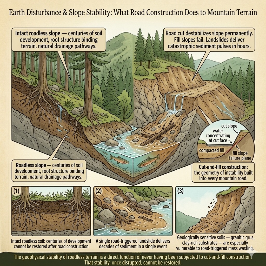
Road construction in mountain terrain does not happen on flat ground. It happens on slopes — and slopes are not passive. They are dynamic systems in which soil, water, and gravity exist in a continuous negotiation. Cut a road into a steep hillside, and you have changed the terms of that negotiation permanently.
The cut slope above a mountain road is a perpetual source of instability. Rain falls on bare mineral soil that has no root structure to hold it. Freeze-thaw cycles crack and loosen rock. Water that would have moved through intact soil now concentrates at the cut face and emerges as seeps that saturate the fill below. Fill slopes — the material pushed downhill during road construction — are inherently unstable: compacted without the centuries of soil development that gives natural slopes their cohesion, they fail. Landslides, debris flows, and chronic surface erosion are not accidents on mountain roads. They are consequences built into the geometry of construction.
This is distinct from the ongoing surface runoff and stream sedimentation that road operation generates — those are captured under sedimentation and water quality. What 7.3 Earth & Sediment Management addresses is the active manipulation of the geophysical environment: the cut-and-fill earthworks, the drainage structures, the slope modifications that fundamentally alter the terrain and its relationship with water and gravity. In roadless areas, these modifications have never occurred. The slopes are intact. Their soils have developed in place for centuries. Their drainage patterns are natural.
In areas with particular geological sensitivity — the granitic decomposed soils of the Sierra Nevada, the steep unstable terrain of the Tongass, the clay-rich soils of parts of the Southern Appalachians — road construction triggers mass wasting events of a scale that dwarfs normal surface erosion. A single landslide triggered by road construction can deliver in a day the sediment that a stream would otherwise accumulate over decades. For downstream aquatic ecosystems already under pressure, these episodic events are not recoverable on any management timescale.
In the roadless areas covered by this application: 24 species carry documented earth disturbance and slope stability threats across 1,694 areas — including 10 critically imperiled (G1/T1) species and 16 federally listed species. The relatively low species count belies the geographic breadth: nearly three-quarters of all roadless areas contain terrain where road-triggered mass wasting is a documented risk. The threat operates primarily at the ecosystem and watershed level rather than species by species.
The geophysical stability of roadless terrain is a direct function of never having been subjected to cut-and-fill construction. That stability, once disrupted, cannot be restored.
Severity of Impact
NatureServe rates the expected population decline for each species facing this threat, using the IUCN-CMP international standard.
Species at Risk
Imperiled species (G1-G3 or federally listed) with NatureServe-assessed threat records in this category. Sort and filter to explore.
| Species | Rank | ESA | Threat | Severity ▲ | Scope | Areas |
|---|---|---|---|---|---|---|
| Suckley's Cuckoo Bumble Bee Bombus suckleyi | G2 | PE | 7.3 Other ecosystem modifications | Extreme or 71-100% pop. decline | Restricted (11-30%) | 1266 |
| Sharpnose Shiner Notropis oxyrhynchus | G3 | E | 7.3 Other ecosystem modifications | Extreme - moderate | Unknown | 1 |
| California Least Tern Sternula antillarum browni | T2 | E | 7.3 Other ecosystem modifications | Extreme - serious | Pervasive - large | 23 |
| Short-tailed Kingsnake Lampropeltis extenuata | G2 | PT | 7.3 Other ecosystem modifications | Extreme - serious | Small (1-10%) | 1 |
| Threadleaf Brodiaea Brodiaea filifolia | G2 | T | 7.3 Other ecosystem modifications | Extreme - serious | Pervasive - large | 13 |
| Addison's Leatherflower Clematis addisonii | G1 | 7.3 Other ecosystem modifications | Serious or 31-70% pop. decline | Restricted (11-30%) | 2 | |
| San Diego Button-celery Eryngium aristulatum var. parishii | T1 | E | 7.3 Other ecosystem modifications | Serious or 31-70% pop. decline | Pervasive - large | 5 |
| San Diego Ragweed Ambrosia pumila | G1 | E | 7.3 Other ecosystem modifications | Serious or 31-70% pop. decline | Pervasive (71-100%) | 6 |
| Decurrent False Aster Boltonia decurrens | G2 | T | 7.3 Other ecosystem modifications | Serious or 31-70% pop. decline | Pervasive - large | 1 |
| White Sturgeon Acipenser transmontanus | G3 | 7.3 Other ecosystem modifications | Serious or 31-70% pop. decline | Pervasive (71-100%) | 1 | |
| Georgia Rockcress Arabis georgiana | G1 | T | 7.3 Other ecosystem modifications | Serious - moderate | Large (31-70%) | 3 |
| Brown Gartersnake Thamnophis eques megalops | T3 | T | 7.3 Other ecosystem modifications | Serious - slight | Pervasive - restricted | 13 |
| Shasta Crayfish Pacifastacus fortis | G1 | E | 7.3 Other ecosystem modifications | Moderate or 11-30% pop. decline | Large (31-70%) | 4 |
| Pinyon Jay Gymnorhinus cyanocephalus | G3 | UR | 7.3 Other ecosystem modifications | Moderate or 11-30% pop. decline | Large (31-70%) | 566 |
| Texas Kangaroo Rat Dipodomys elator | G2 | PE | 7.3 Other ecosystem modifications | Moderate - slight | Large (31-70%) | 1 |
| Chipola Slabshell Elliptio chipolaensis | G1 | T, PDL | 7.3 Other ecosystem modifications | Slight or 1-10% pop. decline | Small (1-10%) | 1 |
| Party-colored Monkeyflower Erythranthe discolor | G3 | 7.3 Other ecosystem modifications | Slight or 1-10% pop. decline | Restricted (11-30%) | 7 | |
| Black Toad Anaxyrus exsul | G1 | 7.3 Other ecosystem modifications | — | — | 5 | |
| Ouachita Rock Pocketbook Arcidens wheeleri | G1 | E | 7.3 Other ecosystem modifications | — | — | 1 |
| Owens Pupfish Cyprinodon radiosus | G1 | E | 7.3 Other ecosystem modifications | — | — | 30 |
| Yellowfin Madtom Noturus flavipinnis | G1 | T, XN | 7.3 Other ecosystem modifications | Unknown | Large - small | 12 |
| Small Whorled Pogonia Isotria medeoloides | G2 | T | 7.3 Other ecosystem modifications | Unknown | Unknown | 88 |
| Navasota Ladies'-tresses Spiranthes parksii | G3 | E | 7.3 Other ecosystem modifications | Unknown | Unknown | 1 |
| Steller Sea Lion Eumetopias jubatus | G3 | E, DL | 7.3 Other ecosystem modifications | Unknown | Pervasive - large | 65 |
Areas at Risk
Roadless areas where imperiled species face this threat, grouped by state.
Arizona (5)
| Area | Forest | Acres | Species at Risk |
|---|---|---|---|
| Mazatzal | Tonto National Forest | 16,942 | 4 |
| Hackberry | Coconino National Forest | 17,885 | 3 |
| Hellsgate | Tonto National Forest | 6,171 | 3 |
| Lime Creek | Tonto National Forest | 42,568 | 3 |
| Muldoon | Prescott National Forest | 5,821 | 3 |
California (10)
| Area | Forest | Acres | Species at Risk |
|---|---|---|---|
| Birch Creek | Inyo National Forest | 28,816 | 3 |
| Black Canyon | Inyo National Forest | 32,421 | 3 |
| Boundary Peak (CA) | Inyo National Forest | 210,884 | 3 |
| Coldwater | Cleveland National Forest | 8,402 | 3 |
| Cutca Valley | Cleveland National Forest | 14,530 | 3 |
| Paiute | Inyo National Forest | 58,712 | 3 |
| San Mateo Canyon | Cleveland National Forest | 65 | 3 |
| Soldier Canyon | Inyo National Forest | 40,589 | 3 |
| Trabuco | Cleveland National Forest | 23,341 | 3 |
| Wildhorse | Cleveland National Forest | 1,483 | 3 |
Idaho (1)
| Area | Forest | Acres | Species at Risk |
|---|---|---|---|
| Bear Creek | Caribou-Targhee National Forest | 118,582 | 3 |
New Mexico (1)
| Area | Forest | Acres | Species at Risk |
|---|---|---|---|
| Contiguous To Gila Wilderness & Primitive Area | Gila National Forest | 79,049 | 3 |
Texas (1)
| Area | Forest | Acres | Species at Risk |
|---|---|---|---|
| Big Creek | National Forests in Texas | 1,447 | 4 |
Utah (29)
| Area | Forest | Acres | Species at Risk |
|---|---|---|---|
| 0401001 | Ashley National Forest | 11,705 | 2 |
| 0401002 | Ashley National Forest | 36,113 | 2 |
| 0401005 | Ashley National Forest | 38,930 | 2 |
| 0401007 | Ashley National Forest | 16,483 | 2 |
| 0401009 | Ashley National Forest | 30,378 | 2 |
| 0401014 | Ashley National Forest | 26,903 | 2 |
| 0401016 | Ashley National Forest | 5,695 | 2 |
| 0401023 | Ashley National Forest | 8,352 | 2 |
| 0401024 | Ashley National Forest | 12,882 | 2 |
| 0401025 | Ashley National Forest | 1,471 | 2 |
| 0401026 | Ashley National Forest | 398 | 2 |
| 0401027 | Ashley National Forest | 7,312 | 2 |
| 0401028 | Ashley National Forest | 446 | 2 |
| 0401031 | Ashley National Forest | 7,110 | 2 |
| 0401032 | Ashley National Forest | 6,471 | 2 |
| 0401037 | Ashley National Forest | 1,166 | 2 |
| 0418033 | Ashley National Forest | 24,909 | 2 |
| 0419020 | Ashley National Forest | 355,684 | 2 |
| 418003 | Uinta National Forest | 10,912 | 2 |
| 418004 | Uinta National Forest | 16,661 | 2 |
| 418012 | Uinta National Forest | 25,758 | 2 |
| 418014 | Uinta National Forest | 9,683 | 2 |
| 418016 | Uinta National Forest | 35,240 | 2 |
| 418017 | Uinta National Forest | 19,631 | 2 |
| 418019 | Uinta National Forest | 6,854 | 2 |
| 418021 | Uinta National Forest | 6,255 | 2 |
| 418022 | Uinta National Forest | 17,289 | 2 |
| 418024 | Uinta National Forest | 51,699 | 2 |
| 418025 | Uinta National Forest | 32,698 | 2 |
IUCN Threat Classification
Official definitions from the IUCN-CMP Unified Classification of Direct Threats.
7.3 — Earth & Sediment Management (v4.0)
Co-occurring Threats
Roads rarely cause a single type of harm. This threat frequently co-occurs with:
Data Sources
- NatureServe Explorer: species threat assessments using IUCN-CMP v3.2
- IUCN-CMP Threat Category 7.3
- IUCN-CMP v4.0: Salafsky et al., Conservation Biology, 2025
Earth Disturbance & Slope Stability