Roads & Ground Disturbance
Road construction is the enabling condition for nearly every major threat these lands face.
The Threat
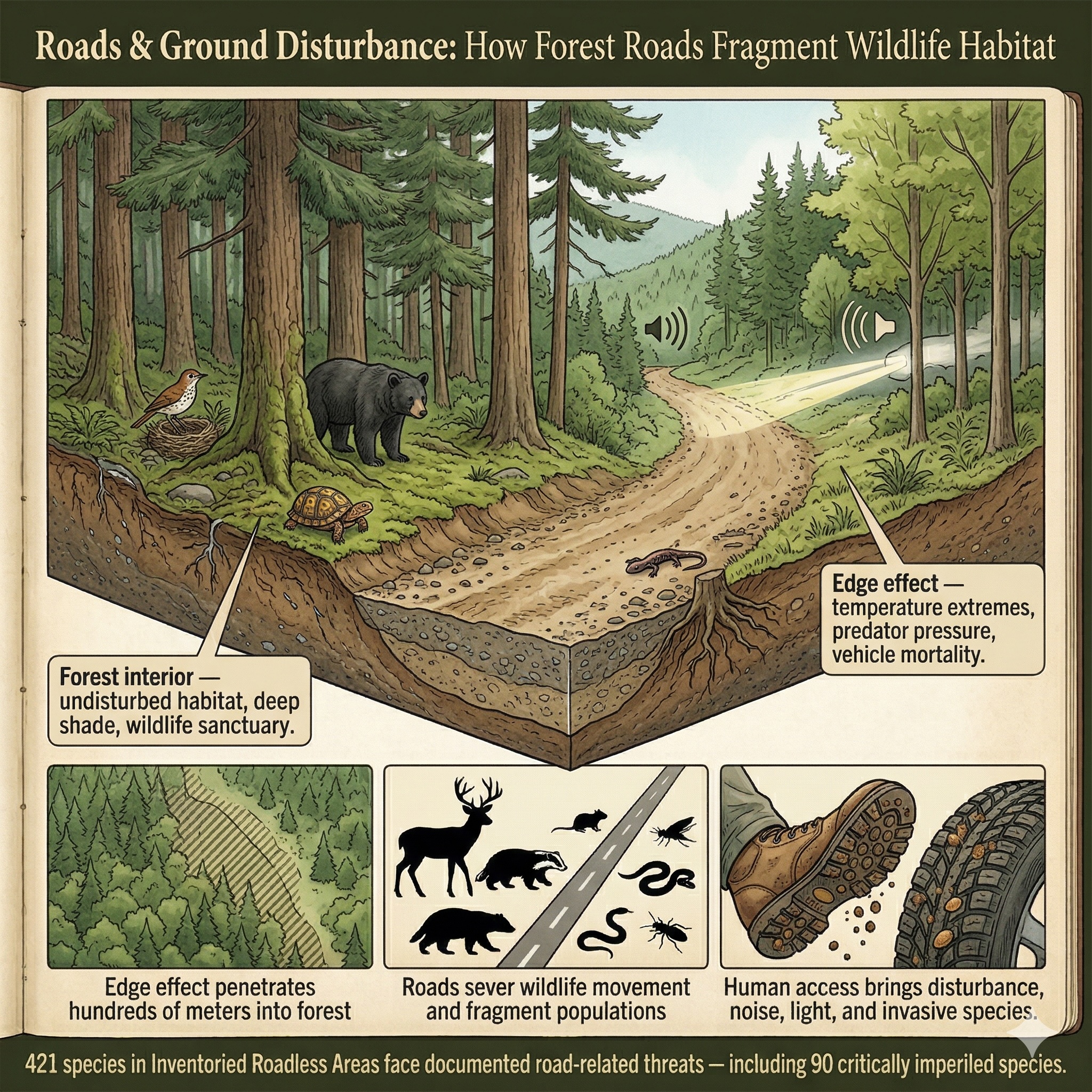
There is a phenomenon ecologists call the "edge effect." When a road is cut through a forest, it does not simply remove a strip of habitat equal to its width. It changes the ecology of the forest on both sides — sometimes for hundreds of meters. Light pours in where canopy once filtered it. Temperature swings become more extreme. Wind penetrates deeper. Predators that follow forest edges move in. The deep interior — the part of the forest that has never "seen" the outside — shrinks.
Interior forest is not the same as edge forest. Many of the most sensitive species — certain warblers, woodland salamanders, wide-ranging mammals — require interior. They evolved in it. They cannot use the edge. When a road divides a forest, it doesn't just cut it in half. It converts interior to edge, and edge is not what those species need.
Beyond the edge effect, road construction brings direct mortality. Vehicles kill wildlife — from the dramatic (a bear struck on a mountain highway) to the invisible (the thousands of salamanders and snakes that die crossing roads on rainy nights, uncounted and unremarked). Roads bring light and noise into ecosystems that have known neither. They bring people, and with people come the concentrated recreational pressures — foot traffic, off-road vehicles, campsites — that disperse disturbance across the landscape.
The official definition of code 4.1 Roads, Trails & Railroads covers "transport on roadways and dedicated tracks" — and its official exposition notes that these corridors "create specific stresses to biodiversity including especially loss and fragmentation of habitats and direct killing of wildlife" and that they "lead to other threats including the spread of invasive species." Version 4.0 expanded this category to explicitly include trails, recognizing that even non-motorized paths share many of these consequences.
In the roadless areas covered by this application: 421 species carry documented road-related threats — including 90 critically imperiled species facing a very high risk of extinction, and 122 imperiled species. These are professional assessments, made species by species, of documented pressure from transportation infrastructure on populations already struggling.
Road construction is the direct threat. Every cut, every fill, every stream crossing removes habitat and opens previously protected areas to the full cascade of human-caused disturbance.
Severity of Impact
NatureServe rates the expected population decline for each species facing this threat, using the IUCN-CMP international standard.
Species at Risk
Imperiled species (G1-G3 or federally listed) with NatureServe-assessed threat records in this category. Sort and filter to explore.
| Species | Rank | ESA | Threat | Severity ▲ | Scope | Areas |
|---|---|---|---|---|---|---|
Townsendia lemhiensis | G1 | 4.1 Roads & railroads | Extreme or 71-100% pop. decline | Small (1-10%) | 3 | |
| Blunt-nosed Leopard Lizard Gambelia sila | G1 | E | 4.1 Roads & railroads | Extreme - moderate | Large - small | 1 |
| Dwarf Bear-poppy Arctomecon humilis | G1 | E | 4.2 Utility & service lines | Extreme or 71-100% pop. decline | Restricted (11-30%) | 2 |
| Fish Slough Milkvetch Astragalus lentiginosus var. piscinensis | T1 | T | 6.1 Recreational activities | Extreme or 71-100% pop. decline | Large (31-70%) | 3 |
| Frank Smith's Violet Viola frank-smithii | G1 | 6.1 Recreational activities | Extreme - moderate | Pervasive (71-100%) | 2 | |
| Giant Kangaroo Rat Dipodomys ingens | G1 | E | 4.1 Roads & railroads | Extreme - moderate | Restricted - small | 15 |
| Ash Grey Indian-paintbrush Castilleja cinerea | G1 | T | 6.1 Recreational activities | Extreme - serious | Pervasive - large | 5 |
| Burke's Goldfields Lasthenia burkei | G1 | E | 6.1 Recreational activities | Extreme - serious | Pervasive - large | 7 |
| Cushenbury Milkvetch Astragalus albens | G1 | E | 4.1 Roads & railroads | Extreme - serious | Pervasive - large | 3 |
| Addison's Leatherflower Clematis addisonii | G1 | 4.1 Roads & railroads | Serious or 31-70% pop. decline | Restricted (11-30%) | 2 | |
| Applegate's Milkvetch Astragalus applegatei | G1 | E | 4.2 Utility & service lines | Serious or 31-70% pop. decline | Restricted (11-30%) | 1 |
| Desert Yellowhead Yermo xanthocephalus | G1 | T | 6.1 Recreational activities | Serious or 31-70% pop. decline | Pervasive (71-100%) | 2 |
| Fassett's Locoweed Oxytropis campestris var. chartacea | T1 | T | 6.1 Recreational activities | Serious or 31-70% pop. decline | Large (31-70%) | 1 |
| Kern Primrose Sphinx Moth Euproserpinus euterpe | G1 | T | 6.1 Recreational activities | Serious or 31-70% pop. decline | Restricted (11-30%) | 6 |
| Long Valley Speckled Dace Rhinichthys nevadensis caldera | T1 | PE | 6.1 Recreational activities | Serious or 31-70% pop. decline | Pervasive (71-100%) | 3 |
| Bear Valley Sandwort Eremogone ursina | G1 | T | 6.1 Recreational activities | Serious - moderate | Pervasive (71-100%) | 2 |
| Cheat Mountain Salamander Plethodon nettingi | G1 | T | 4.1 Roads & railroads | Serious - moderate | Small (1-10%) | 7 |
| Cushenbury Buckwheat Eriogonum ovalifolium var. vineum | T1 | E | 6.1 Recreational activities | Serious - moderate | Pervasive - large | 2 |
| Epling's Hedge-nettle Stachys eplingii | G1 | 4.1 Roads & railroads | Serious - moderate | Restricted (11-30%) | 3 | |
| Georgia Rockcress Arabis georgiana | G1 | T | 4.1 Roads & railroads | Serious - moderate | Large (31-70%) | 3 |
| Louisiana Pinesnake Pituophis ruthveni | G1 | T | 4.1 Roads & railroads | Serious - moderate | Restricted (11-30%) | 2 |
| Banbury Springs Limpet Idaholanx fresti | G1 | E | 6.1 Recreational activities | Serious - slight | Large - restricted | 1 |
| Contra Costa Goldfields Lasthenia conjugens | G1 | E | 4.1 Roads & railroads | Serious - slight | Large - small | 6 |
| Jemez Mountains Salamander Plethodon neomexicanus | G1 | E | 4.1 Roads & railroads | Serious - slight | Restricted - small | 21 |
| Little Colorado Spinedace Lepidomeda vittata | G1 | T | 4.1 Roads & railroads | Serious - slight | Unknown | 3 |
| Agate Desert Lomatium Lomatium cookii | G1 | E | 6.1 Recreational activities | Moderate or 11-30% pop. decline | Large (31-70%) | 1 |
| Barneby's Pepper-grass Lepidium barnebyanum | G1 | E | 6.1 Recreational activities | Moderate or 11-30% pop. decline | Restricted - small | 3 |
| California Dandelion Taraxacum californicum | G1 | E | 6.1 Recreational activities | Moderate or 11-30% pop. decline | Large (31-70%) | 2 |
| California Jewelflower Caulanthus californicus | G1 | E | 4.1 Roads & railroads | Moderate or 11-30% pop. decline | Large - restricted | 14 |
| Clay Phacelia Phacelia argillacea | G1 | E | 4.1 Roads & railroads | Moderate or 11-30% pop. decline | Restricted (11-30%) | 11 |
| Encinitis Baccharis Baccharis vanessae | G1 | T | 6.1 Recreational activities | Moderate or 11-30% pop. decline | Pervasive - large | 2 |
| Green's Awnless Orcutt Grass Tuctoria greenei | G1 | E | 6.1 Recreational activities | Moderate or 11-30% pop. decline | Large - restricted | 24 |
| Hawaiian Petrel Pterodroma sandwichensis | G1 | E | 4.2 Utility & service lines | Moderate or 11-30% pop. decline | Pervasive - large | 4 |
| Holy Ghost Ipomopsis Ipomopsis sancti-spiritus | G1 | E | 6.1 Recreational activities | Moderate or 11-30% pop. decline | Large - restricted | 14 |
| Clay-loving Wild Buckwheat Eriogonum pelinophilum | G1 | E | 6.1 Recreational activities | Moderate - slight | Large - restricted | 1 |
| Cushion Bladderpod Physaria pulvinata | G1 | 6.1 Recreational activities | Moderate - slight | Restricted (11-30%) | 1 | |
| Frosted Flatwoods Salamander Ambystoma cingulatum | G1 | T | 4.1 Roads & railroads | Moderate - slight | Restricted (11-30%) | 4 |
| Gray's Lily Lilium grayi | G1 | 6.1 Recreational activities | Moderate - slight | Small (1-10%) | 10 | |
| Great Lakes Jacob's-ladder Polemonium lacustre | G1 | 4.1 Roads & railroads | Moderate - slight | Restricted (11-30%) | 1 | |
| James Spinymussel Parvaspina collina | G1 | E | 4.1 Roads & railroads | Moderate - slight | Restricted (11-30%) | 16 |
| Kendall Warm Springs Dace Rhinichthys osculus thermalis | T1 | E | 4.1 Roads & railroads | Moderate - slight | Restricted (11-30%) | 5 |
| Arroyo Toad Anaxyrus californicus | G1 | E | 6.1 Recreational activities | Slight or 1-10% pop. decline | Large - restricted | 48 |
| Benton County Cave Crayfish Cambarus aculabrum | G1 | E | 6.1 Recreational activities | Slight or 1-10% pop. decline | Small (1-10%) | 1 |
| Bruneau Hot Springsnail Pyrgulopsis bruneauensis | G1 | E | 6.1 Recreational activities | Slight or 1-10% pop. decline | Small (1-10%) | 22 |
| California Condor Gymnogyps californianus | G1 | E, XN | 4.2 Utility & service lines | Slight or 1-10% pop. decline | Pervasive (71-100%) | 344 |
| Chipola Slabshell Elliptio chipolaensis | G1 | T, PDL | 4.1 Roads & railroads | Slight or 1-10% pop. decline | Small (1-10%) | 1 |
| Eastern Black Rail Laterallus jamaicensis jamaicensis | T1 | T | 6.1 Recreational activities | Negligible or <1% pop. decline | Small (1-10%) | 29 |
| Kremmling Beardtongue Penstemon penlandii | G1 | E | 4.2 Utility & service lines | Slight or 1-10% pop. decline | Large (31-70%) | 3 |
| Laguna Mountains Skipper Pyrgus ruralis lagunae | T1 | E | 6.1 Recreational activities | Slight or 1-10% pop. decline | Large (31-70%) | 2 |
| Kelso Creek Monkeyflower Erythranthe shevockii | G1 | 4.1 Roads & railroads | Unknown | Restricted (11-30%) | 5 |
Showing top 50 species. Use filters above to narrow results.
Areas at Risk
Roadless areas where imperiled species face this threat, grouped by state.
Arkansas (1)
| Area | Forest | Acres | Species at Risk |
|---|---|---|---|
| Brush Heap | Ouachita National Forest | 4,205 | 10 |
California (24)
| Area | Forest | Acres | Species at Risk |
|---|---|---|---|
| Rincon | Sequoia National Forest | 54,610 | 15 |
| Trabuco | Cleveland National Forest | 23,341 | 15 |
| Wildhorse | Cleveland National Forest | 1,483 | 15 |
| Chico | Sequoia National Forest | 39,836 | 14 |
| Greenhorn Creek | Sequoia National Forest | 28,226 | 14 |
| Channell | Sequoia National Forest | 45,429 | 13 |
| Orleans Mtn. | Klamath National Forest | 49,090 | 13 |
| Woolstaff | Sequoia National Forest | 41,445 | 13 |
| Coldwater | Cleveland National Forest | 8,402 | 12 |
| Domeland Add. | Sequoia National Forest | 3,046 | 12 |
| Mill Creek | Sequoia National Forest | 27,643 | 12 |
| Sespe - Frazier | Los Padres National Forest | 106,910 | 12 |
| Slate Mtn. | Sequoia National Forest | 12,299 | 12 |
| Fox Mountain | Los Padres National Forest | 52,072 | 11 |
| Sawmill - Badlands | Los Padres National Forest | 51,362 | 11 |
| Siskiyou | Klamath National Forest | 54,039 | 11 |
| Tule | Angeles National Forest | 9,861 | 11 |
| Cajon | San Bernardino National Forest | 7,548 | 10 |
| Granite Peak | San Bernardino National Forest | 450 | 10 |
| Juncal | Los Padres National Forest | 12,289 | 10 |
| Kings River | Sierra National Forest | 52,999 | 10 |
| Moses | Sequoia National Forest | 22,077 | 10 |
| San Dimas | Angeles National Forest | 7,160 | 10 |
| Sheep Mountain | Angeles National Forest | 21,098 | 10 |
Florida (3)
| Area | Forest | Acres | Species at Risk |
|---|---|---|---|
| Savannah | Apalachicola National Forest | 1,927 | 16 |
| Gum Bay | Apalachicola National Forest | 11,645 | 11 |
| Alexander Springs Creek | Ocala National Forest | 2,954 | 10 |
Georgia (2)
| Area | Forest | Acres | Species at Risk |
|---|---|---|---|
| Pink Knob | Chattahoochee National Forest | 12,127 | 11 |
| Sarah's Creek | Chattahoochee National Forest | 6,888 | 10 |
Idaho (1)
| Area | Forest | Acres | Species at Risk |
|---|---|---|---|
| Bear Creek | Caribou-Targhee National Forest | 118,582 | 20 |
North Carolina (11)
| Area | Forest | Acres | Species at Risk |
|---|---|---|---|
| Graveyard Ridge (addition) | Pisgah National Forest | 1,958 | 16 |
| Sam Knob (addition) | Pisgah National Forest | 2,576 | 15 |
| Bearwallow | Pisgah National Forest | 4,113 | 13 |
| Harper Creek | Pisgah National Forest | 7,325 | 13 |
| Lost Cove | Pisgah National Forest | 5,944 | 13 |
| Snowbird | Nantahala National Forest | 8,489 | 12 |
| Laurel Mountain | Pisgah National Forest | 5,683 | 11 |
| Balsam Cone | Pisgah National Forest | 10,591 | 10 |
| Cheoah Bald | Nantahala National Forest | 7,795 | 10 |
| Chunky Gal (addition) | Nantahala National Forest | 3,336 | 10 |
| Middle Prong Addition | Pisgah National Forest | 1,852 | 10 |
Oklahoma (1)
| Area | Forest | Acres | Species at Risk |
|---|---|---|---|
| Beech Creek | Ouachita National Forest | 8,303 | 11 |
South Dakota (1)
| Area | Forest | Acres | Species at Risk |
|---|---|---|---|
| Indian Creek | Buffalo Gap National Grassland | 24,666 | 46 |
Tennessee (1)
| Area | Forest | Acres | Species at Risk |
|---|---|---|---|
| Brushy Ridge | Cherokee National Forest | 7,469 | 10 |
Texas (1)
| Area | Forest | Acres | Species at Risk |
|---|---|---|---|
| Big Creek | National Forests in Texas | 1,447 | 11 |
Utah (1)
| Area | Forest | Acres | Species at Risk |
|---|---|---|---|
| Pine Valley Mountains | Dixie National Forest | 57,673 | 10 |
Virginia (2)
| Area | Forest | Acres | Species at Risk |
|---|---|---|---|
| Little Alleghany | George Washington National Forest | 10,215 | 11 |
| Mill Mountain | George Washington National Forest | 10,840 | 11 |
West Virginia (1)
| Area | Forest | Acres | Species at Risk |
|---|---|---|---|
| Seneca Creek | Monongahela National Forest | 22,287 | 10 |
IUCN Threat Classification
Official definitions from the IUCN-CMP Unified Classification of Direct Threats.
4.1 — Roads, Trails & Railroads (v4.0)
4.2 — Utility & Service Lines (v4.0)
6.1 — Recreational Activities (v4.0)
6.3 — Other Human Disturbances (v4.0)
Co-occurring Threats
Roads rarely cause a single type of harm. This threat frequently co-occurs with:
Data Sources
- NatureServe Explorer: species threat assessments using IUCN-CMP v3.2
- IUCN-CMP Threat Categories 4.1, 4.2, 6.1, 6.3
- IUCN-CMP v4.0: Salafsky et al., Conservation Biology, 2025
Roads & Ground Disturbance