Threats to Roadless Areas
Road construction is not one threat — it is the enabling condition for most of the major threats that imperiled species and ecosystems face on National Forest lands.
The Inventoried Roadless Areas exist in their current ecological condition because roads were never built. Rescinding the Roadless Rule permits road construction, activating a cascade of harm documented by NatureServe, the IUCN, and the U.S. Fish & Wildlife Service.
What We Mean When We Say "Threat"

Picture a stream in the southern Appalachians in late summer. The water is cold enough that your hand aches within seconds. On the streambed, beneath a slab of sandstone, a creature the length of your forearm has been living in the same territory for thirty years. The Eastern Hellbender — North America's largest salamander — breathes almost entirely through the folds of skin along its sides, which means it needs water that is clean, clear, and oxygen-rich. It has been here, in streams like this, for 65 million years.
Now consider what happens when a road is built up the hollow above that stream.
The graded roadbed sheds rainwater instead of absorbing it. That water picks up fine soil particles and carries them downhill into the stream, where they settle between the gravel cobbles the Hellbender needs for shelter and spawning. The water clouds. Oxygen drops. The insect larvae the Hellbender hunts become scarce. The eggs it lays in gravel nests are smothered. The animal that survived the asteroid that killed the dinosaurs begins to disappear from streams where it has lived longer than our species has existed.
This is what a threat looks like. Not an abstraction — a specific, documented, mechanistic chain from human action to ecological consequence.
The data in this application speaks a precise scientific language for describing those chains. Understanding it is understanding what is actually at stake.
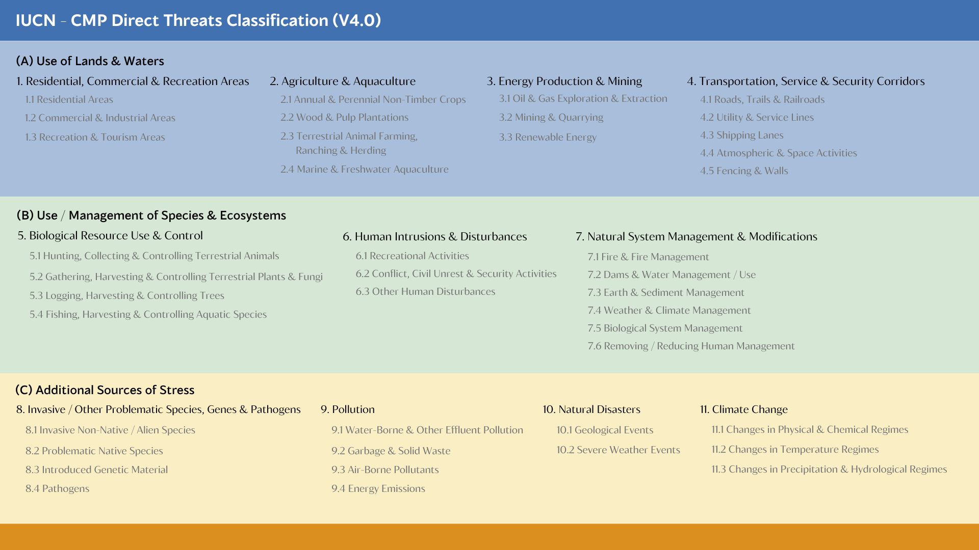
The IUCN Classification: A Common Language for a Global Crisis
In 2008, the International Union for Conservation of Nature and the Conservation Measures Partnership recognized a problem. Conservation scientists around the world were documenting threats to species and ecosystems — but using different words for the same things. One team called it "cattle." Another called it "livestock." A third called it "grazing." They were all describing the same threat, but their data couldn't talk to each other.
The solution was the same one Linnaeus applied to living organisms three centuries earlier: a shared, hierarchical classification system. If every team agreed to tag their cattle threat as "2.3 Terrestrial Animal Farming, Ranching & Herding," the data became comparable across continents, species groups, and decades.
Version 4.0 of this classification — published in 2025 by Salafsky and colleagues in Conservation Biology — is the current international standard. It is used by the IUCN Red List, by NatureServe, and by conservation agencies in dozens of countries. When a species in this database carries a threat code like 8.1 or 4.1, that code was assigned by professional ecologists at NatureServe using this same international standard — the same language used to assess the Snow Leopard in Central Asia or the Atlantic Sturgeon in the rivers of France.
The classification organizes threats into eleven broad categories, each divided into specific subcategories. Each entry carries an official definition — what the threat is — and an exposition — guidance on how to apply it and where it fits relative to adjacent categories. These are the authoritative descriptions. What follows uses them directly.
The Central Argument: Roads Unlock Every Other Threat
Stand at the edge of an Inventoried Roadless Area. What you're standing at the edge of is not simply a place without pavement. You're standing at the edge of a different ecological reality — one where the cascade of consequences that follows road construction has not yet begun.
A road is not one thing. It is many things simultaneously: a path for logging equipment and mining vehicles; a corridor along which invasive species travel on tire treads and boot soles; a source of sediment that enters streams whenever it rains; an ignition point for wildfire; a barrier that severs the movement of animals across the landscape; an enabler of grazing intensification and livestock infrastructure; a delivery mechanism for pathogens into previously isolated terrain; a structure that blocks fish passage at every stream it crosses; a signal to every opportunistic land use that the terrain is now accessible.
The ten threat themes documented in this application are not ten separate problems. They are ten faces of one decision — whether to build roads.
The Notice of Intent that initiated this rulemaking states its purpose plainly. The proposed rescission responds directly to Executive Order 14154, Unleashing American Energy, and Executive Order 14225, Immediate Expansion of American Timber Production — federal directives declaring that energy, mineral, and timber production must be facilitated "to the maximum possible extent" on public lands. The ecological consequences of that intent are not speculative. For the species and ecosystems documented here, they are already measured, already recorded, already expressed in the language of international conservation science.
Threats Enabled by Road Construction
Roads & Ground Disturbance
Road construction is the enabling condition for nearly every major threat these lands face.
Logging & Timber Harvest
Commercial timber extraction is economically infeasible without road access.
Invasive Species
Roads are the primary vector for non-native species introduction into wildlands.
Fire Regime Alteration
Road access enables fire suppression that degrades fire-dependent ecosystems, while increasing human-caused ignitions.
Sedimentation & Water Quality
Forest roads generate more sediment per unit area than any other land use in national forests.
Extractive Industries — Mining & Energy
The proposed rescission responds to executive orders declaring that energy and mineral production must be facilitated on public lands.
Grazing & Ranching
Road construction enables the infrastructure that intensifies grazing pressure in remote terrain historically too inaccessible for intensive management.
Aquatic Passage & Hydrological Connectivity
Road stream crossings — culverts and bridges — are the most pervasive barrier to fish passage in national forests. Roadless areas have none.
Earth Disturbance & Slope Stability
Road construction in mountain terrain triggers slope instability, landslides, and mass wasting across nearly three-quarters of all roadless areas.
Climate Change & Refugia Function
Roadless areas function as climate refugia — intact forest, cold headwater streams, and unbroken elevation gradients buffer species against warming. Road construction degrades all of these functions.
Data Sources
Threat assessments are from NatureServe Explorer, using the IUCN-CMP Unified Classification of Direct Threats (v3.2) — the international standard used by the IUCN Red List, NatureServe, and conservation agencies worldwide. Species conservation ranks (G-ranks) are from NatureServe, used by all 50 state Natural Heritage Programs, USFWS, and USFS. Federal listing status is from the U.S. Fish & Wildlife Service Information for Planning and Consultation (IPaC). Species observations are from iNaturalist (research-grade) and USFWS IPaC range data.