Sedimentation & Water Quality
Forest roads generate more sediment per unit area than any other land use in national forests.
The Threat
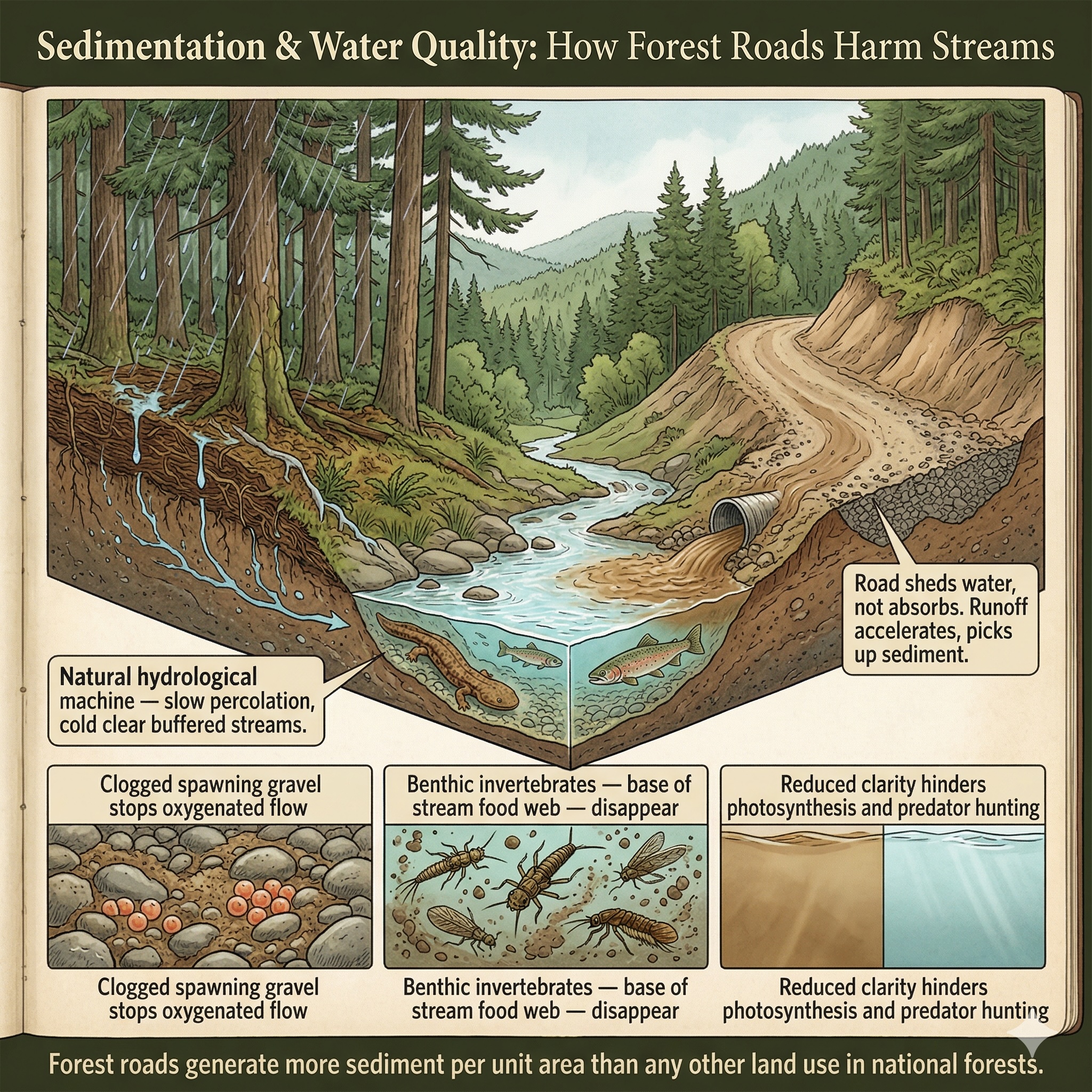
Water moves downhill. Everything a road puts into the landscape eventually follows.
A natural forest floor is an extraordinary hydrological machine. Rain hits the canopy, drips to the duff layer, percolates through organic matter, and enters the mineral soil slowly. It emerges in streams cold, clear, and chemically buffered — the product of a filtration system built over centuries of leaf-fall and root growth. A road interrupts this process completely. The graded surface sheds water instead of absorbing it. Runoff accelerates. It picks up fine soil particles as it goes, and those particles travel downslope until they reach the nearest stream.
Forest roads generate more sediment per unit area than almost any other land use in national forests. Stream crossings — culverts and bridges — concentrate the effect, delivering sediment loads directly into the channel. And sediment in a stream is not neutral. It settles into the spaces between gravel and cobble that salmon and trout need for spawning — eggs need oxygenated water flowing through the gravel to survive, and sediment stops that flow. It smothers the benthic invertebrates — the stoneflies, mayflies, and caddisflies — that form the base of stream food webs. It reduces water clarity, affecting everything from photosynthesis in aquatic plants to the ability of predators to hunt by sight.
The species most affected are aquatic, and aquatic species in North America are in profound crisis. Freshwater fish, mussels, and crayfish face extinction rates that dwarf those of terrestrial species — a reflection of how sensitive streams are to disturbance, and how directly connected they are to roads through the physics of water flow.
The IUCN v4.0 classification places road runoff and logging-related erosion explicitly within 9.1 Water-Borne & Other Effluent Pollution, with "oil or sediment from roads" and "erosion from logging operations" named as included sources in the official examples.
In the roadless areas covered by this application: 226 species carry documented sedimentation and water quality threats — including 71 critically imperiled and 65 imperiled species. The aquatic species in these figures are among the most vulnerable in the entire dataset: narrow-range endemics, species with specific gravel-bed requirements, organisms that cannot relocate when their streams are degraded.
Forest roads generate more sediment per unit area than any other land use in national forests. Every road cut, every fill slope, every stream crossing delivers sediment directly into waterways. Roadless watersheds remain clean because the primary sediment source does not exist.
Severity of Impact
NatureServe rates the expected population decline for each species facing this threat, using the IUCN-CMP international standard.
Species at Risk
Imperiled species (G1-G3 or federally listed) with NatureServe-assessed threat records in this category. Sort and filter to explore.
| Species | Rank | ESA | Threat | Severity ▲ | Scope | Areas |
|---|---|---|---|---|---|---|
| Amber Darter Percina antesella | G1 | E | 9.1 Domestic & urban waste water | Extreme - moderate | Unknown | 4 |
| Atlantic Pigtoe Fusconaia masoni | G1 | T | 9.1 Domestic & urban waste water | Extreme or 71-100% pop. decline | Pervasive (71-100%) | 4 |
| Chihuahua Chub Gila nigrescens | G1 | T | 9.1 Domestic & urban waste water | Extreme - moderate | Pervasive - restricted | 3 |
| Conasauga Logperch Percina jenkinsi | G1 | E | 9.1 Domestic & urban waste water | Extreme - moderate | Pervasive - large | 3 |
| Cui-ui Chasmistes cujus | G1 | E | 9.1 Domestic & urban waste water | Extreme - moderate | Pervasive (71-100%) | 15 |
| Ozark Hellbender Cryptobranchus alleganiensis bishopi | T1 | E | 9.1 Domestic & urban waste water | Extreme - moderate | Pervasive - restricted | 3 |
| Blue Shiner Cyprinella caerulea | G2 | T | 9.1 Domestic & urban waste water | Extreme - moderate | Large - restricted | 4 |
| Etowah Darter Nothonotus etowahae | G2 | E | 9.1 Domestic & urban waste water | Extreme - moderate | Pervasive - restricted | 1 |
| Goldline Darter Percina aurolineata | G2 | T | 9.1 Domestic & urban waste water | Extreme - moderate | Pervasive - restricted | 4 |
| Cumberlandian Combshell Epioblasma brevidens | G1 | E, XN | 9.3.2 Soil erosion, sedimentation | Serious or 31-70% pop. decline | Large (31-70%) | 1 |
| Fat Threeridge Amblema neislerii | G1 | E, PDL | 9.1 Domestic & urban waste water | Serious or 31-70% pop. decline | Restricted (11-30%) | 1 |
| Ochlockonee Moccasinshell Medionidus simpsonianus | G1 | E | 9.1 Domestic & urban waste water | Serious or 31-70% pop. decline | Restricted (11-30%) | 2 |
| Oyster Mussel Epioblasma capsaeformis | G1 | E, XN | 9.1 Domestic & urban waste water | Serious or 31-70% pop. decline | Large (31-70%) | 1 |
| Santa Ana Speckled Dace Rhinichthys gabrielino | G1 | PT | 9.1 Domestic & urban waste water | Serious or 31-70% pop. decline | Pervasive (71-100%) | 20 |
| Eastern Hellbender Cryptobranchus alleganiensis alleganiensis | T2 | E, PE | 9.1 Domestic & urban waste water | Serious or 31-70% pop. decline | Large (31-70%) | 65 |
| Appalachian Elktoe Alasmidonta raveneliana | G1 | E | 9.1.2 Run-off | Serious - moderate | Large - restricted | 1 |
| Appalachian Rockshell Theliderma sparsa | G1 | E, XN | 9.1 Domestic & urban waste water | Serious - moderate | Large - restricted | 1 |
| Banbury Springs Limpet Idaholanx fresti | G1 | E | 9.1 Domestic & urban waste water | Serious - moderate | Restricted (11-30%) | 1 |
| Clubshell Pleurobema clava | G1 | E, XN | 9.1 Domestic & urban waste water | Serious - moderate | Large - restricted | 2 |
| Coosa Moccasinshell Medionidus parvulus | G1 | E | 9.3.2 Soil erosion, sedimentation | Serious - moderate | Large - restricted | 5 |
| Cracking Pearlymussel Hemistena lata | G1 | E, XN | 9.1 Domestic & urban waste water | Serious - moderate | Large - restricted | 1 |
| Cumberland Rockshell Theliderma intermedia | G1 | E, XN | 9.3.2 Soil erosion, sedimentation | Serious - moderate | Large (31-70%) | 1 |
| Fanshell Cyprogenia stegaria | G1 | E, XN | 9.1 Domestic & urban waste water | Serious - moderate | Large - restricted | 3 |
| Finerayed Pigtoe Fusconaia cuneolus | G1 | E, XN | 9.1.2 Run-off | Serious - moderate | Large - restricted | 6 |
| James Spinymussel Parvaspina collina | G1 | E | 9.1 Domestic & urban waste water | Serious - moderate | Large - restricted | 16 |
| Northern Riffleshell Epioblasma rangiana | G1 | E | 9.1 Domestic & urban waste water | Serious - moderate | Large - restricted | 1 |
| Ovate Clubshell Pleurobema perovatum | G1 | E | 9.3.2 Soil erosion, sedimentation | Serious - moderate | Large - restricted | 1 |
| Salamander Mussel Simpsonaias ambigua | G1 | PE | 9.1 Domestic & urban waste water | Serious - moderate | Pervasive - large | 8 |
| Shiny Pigtoe Fusconaia cor | G1 | E, XN | 9.3.2 Soil erosion, sedimentation | Serious - moderate | Large - restricted | 6 |
| Southern Pigtoe Pleurobema georgianum | G1 | E | 9.3.2 Soil erosion, sedimentation | Serious - moderate | Large - restricted | 7 |
| Alabama Moccasinshell Medionidus acutissimus | G2 | T | 9.1 Domestic & urban waste water | Serious - moderate | Large - restricted | 3 |
| Fluted Kidneyshell Ptychobranchus subtentus | G2 | E | 9.1 Domestic & urban waste water | Serious - moderate | Large - restricted | 10 |
| Green Floater Lasmigona subviridis | G2 | PT | 9.3.2 Soil erosion, sedimentation | Serious - moderate | Large - restricted | 37 |
| Hine's Emerald Somatochlora hineana | G2 | E | 9.1 Domestic & urban waste water | Serious - moderate | Large - restricted | 3 |
| Benton County Cave Crayfish Cambarus aculabrum | G1 | E | 9.1 Domestic & urban waste water | Serious - slight | Large - restricted | 1 |
| Chipola Slabshell Elliptio chipolaensis | G1 | T, PDL | 9.1 Domestic & urban waste water | Serious - slight | Restricted (11-30%) | 1 |
| Dromedary Pearlymussel Dromus dromas | G1 | E, XN | 9.1 Domestic & urban waste water | Serious - slight | Large - restricted | 1 |
| Pink Mucket Lampsilis abrupta | G1 | E | 9.1 Domestic & urban waste water | Serious - slight | Restricted (11-30%) | 5 |
| Riverside Fairy Shrimp Streptocephalus woottoni | G1 | E | 9.1 Domestic & urban waste water | Serious - slight | Restricted (11-30%) | 22 |
| Cherokee Darter Etheostoma scotti | G2 | T | 9.1 Domestic & urban waste water | Serious - slight | Unknown | 1 |
| Georgia Pigtoe Pleurobema hanleyianum | G1 | E | 9.1 Domestic & urban waste water | Moderate or 11-30% pop. decline | Restricted (11-30%) | 3 |
| Santa Ana Sucker Pantosteus santaanae | G1 | T | 9.1 Domestic & urban waste water | Moderate or 11-30% pop. decline | Pervasive - large | 4 |
| Southern Elktoe Alasmidonta triangulata | G1 | PE | 9.1 Domestic & urban waste water | Moderate or 11-30% pop. decline | Large (31-70%) | 1 |
| Ouachita Rock Pocketbook Arcidens wheeleri | G1 | E | 9.1 Domestic & urban waste water | Moderate - slight | Restricted (11-30%) | 1 |
| Western Fanshell Cyprogenia aberti | G1 | T | 9.1 Domestic & urban waste water | Moderate - slight | Restricted (11-30%) | 6 |
| Texas Fawnsfoot Truncilla macrodon | G1 | T | 9.1 Domestic & urban waste water | — | — | 1 |
| Winged Mapleleaf Quadrula fragosa | G1 | E, XN | 9.1 Domestic & urban waste water | — | — | 1 |
| California Red-legged Frog Rana draytonii | G2 | T | 9.1 Domestic & urban waste water | — | — | 65 |
| Halloween Darter Percina crypta | G2 | UR | 9.1 Domestic & urban waste water | — | — | 1 |
| Junaluska Salamander Eurycea junaluska | G2 | 9.1.2 Run-off | Unknown | Restricted - small | 5 |
Showing top 50 species. Use filters above to narrow results.
Areas at Risk
Roadless areas where imperiled species face this threat, grouped by state.
California (20)
| Area | Forest | Acres | Species at Risk |
|---|---|---|---|
| Blue Creek Rare I | Six Rivers National Forest | 12,134 | 4 |
| Coldwater | Cleveland National Forest | 8,402 | 4 |
| Juncal | Los Padres National Forest | 12,289 | 4 |
| Matilija | Los Padres National Forest | 5,218 | 4 |
| Orleans Mtn. | Klamath National Forest | 49,090 | 4 |
| Red Mountain | Angeles National Forest | 8,034 | 4 |
| San Mateo Canyon | Cleveland National Forest | 65 | 4 |
| Sespe - Frazier | Los Padres National Forest | 106,910 | 4 |
| Siskiyou | Klamath National Forest | 54,039 | 4 |
| Trabuco | Cleveland National Forest | 23,341 | 4 |
| White Ledge | Los Padres National Forest | 18,632 | 4 |
| Wildhorse | Cleveland National Forest | 1,483 | 4 |
| Antimony | Los Padres National Forest | 40,911 | 3 |
| Black Butte | Los Padres National Forest | 5,116 | 3 |
| Bonanza King | Shasta-Trinity National Forest | 16,402 | 3 |
| Chalk Peak | Los Padres National Forest | 7,472 | 3 |
| City Creek | San Bernardino National Forest | 9,997 | 3 |
| Devils Rock | Shasta-Trinity National Forest | 16,209 | 3 |
| Diable | Los Padres National Forest | 19,597 | 3 |
| Domeland Add. | Sequoia National Forest | 3,046 | 3 |
Florida (1)
| Area | Forest | Acres | Species at Risk |
|---|---|---|---|
| Savannah | Apalachicola National Forest | 1,927 | 4 |
Georgia (4)
| Area | Forest | Acres | Species at Risk |
|---|---|---|---|
| Pink Knob | Chattahoochee National Forest | 12,127 | 9 |
| Foster Branch | Chattahoochee National Forest | 171 | 7 |
| Ken Mountain | Chattahoochee National Forest | 527 | 7 |
| Lance Creek | Chattahoochee National Forest | 9,025 | 5 |
Idaho (1)
| Area | Forest | Acres | Species at Risk |
|---|---|---|---|
| Bear Creek | Caribou-Targhee National Forest | 118,582 | 28 |
Illinois (1)
| Area | Forest | Acres | Species at Risk |
|---|---|---|---|
| Burke Branch | Shawnee National Forest | 6,231 | 7 |
Kentucky (1)
| Area | Forest | Acres | Species at Risk |
|---|---|---|---|
| Wolfpen | Daniel Boone National Forest | 2,835 | 5 |
North Carolina (5)
| Area | Forest | Acres | Species at Risk |
|---|---|---|---|
| Snowbird | Nantahala National Forest | 8,489 | 5 |
| Bald Mountain | Pisgah National Forest | 11,085 | 4 |
| Yellowhammer Branch (add.) | Nantahala National Forest | 1,255 | 4 |
| Boteler Peak | Nantahala National Forest | 4,205 | 3 |
| Cheoah Bald | Nantahala National Forest | 7,795 | 3 |
Oklahoma (1)
| Area | Forest | Acres | Species at Risk |
|---|---|---|---|
| Beech Creek | Ouachita National Forest | 8,303 | 3 |
Pennsylvania (1)
| Area | Forest | Acres | Species at Risk |
|---|---|---|---|
| Allegheny Front | Allegheny National Forest | 7,430 | 4 |
South Dakota (1)
| Area | Forest | Acres | Species at Risk |
|---|---|---|---|
| Indian Creek | Buffalo Gap National Grassland | 24,666 | 8 |
Tennessee (7)
| Area | Forest | Acres | Species at Risk |
|---|---|---|---|
| Upper Bald River | Cherokee National Forest | 9,202 | 6 |
| Bald Mountain | Cherokee National Forest | 11,743 | 5 |
| Brushy Ridge | Cherokee National Forest | 7,469 | 5 |
| Little Frog Addition NE | Cherokee National Forest | 321 | 5 |
| Little Frog Addition NW | Cherokee National Forest | 628 | 5 |
| Sycamore Creek | Cherokee National Forest | 6,984 | 4 |
| Bald River Gorge Addition | Cherokee National Forest | 1,728 | 3 |
Texas (1)
| Area | Forest | Acres | Species at Risk |
|---|---|---|---|
| Big Creek | National Forests in Texas | 1,447 | 5 |
Virginia (6)
| Area | Forest | Acres | Species at Risk |
|---|---|---|---|
| Bear Creek | Jefferson National Forest | 18,274 | 8 |
| Hunting Camp Little Wolf Creek | Jefferson National Forest | 8,953 | 8 |
| Beartown Addition A | Jefferson National Forest | 1,370 | 6 |
| Beartown Addition B | Jefferson National Forest | 2,985 | 6 |
| Garden Mountain | Jefferson National Forest | 3,960 | 6 |
| Broad Run | Jefferson National Forest | 10,971 | 3 |
IUCN Threat Classification
Official definitions from the IUCN-CMP Unified Classification of Direct Threats.
9.1 — Water-Borne & Other Effluent Pollution (v4.0)
9.3.2 — Soil Erosion, Sedimentation (v3.2)
Co-occurring Threats
Roads rarely cause a single type of harm. This threat frequently co-occurs with:
Data Sources
- NatureServe Explorer: species threat assessments using IUCN-CMP v3.2
- IUCN-CMP Threat Categories 9.1, 9.3.2
- IUCN-CMP v4.0: Salafsky et al., Conservation Biology, 2025
Sedimentation & Water Quality