Fire Regime Alteration
Road access enables fire suppression that degrades fire-dependent ecosystems, while increasing human-caused ignitions.
The Threat
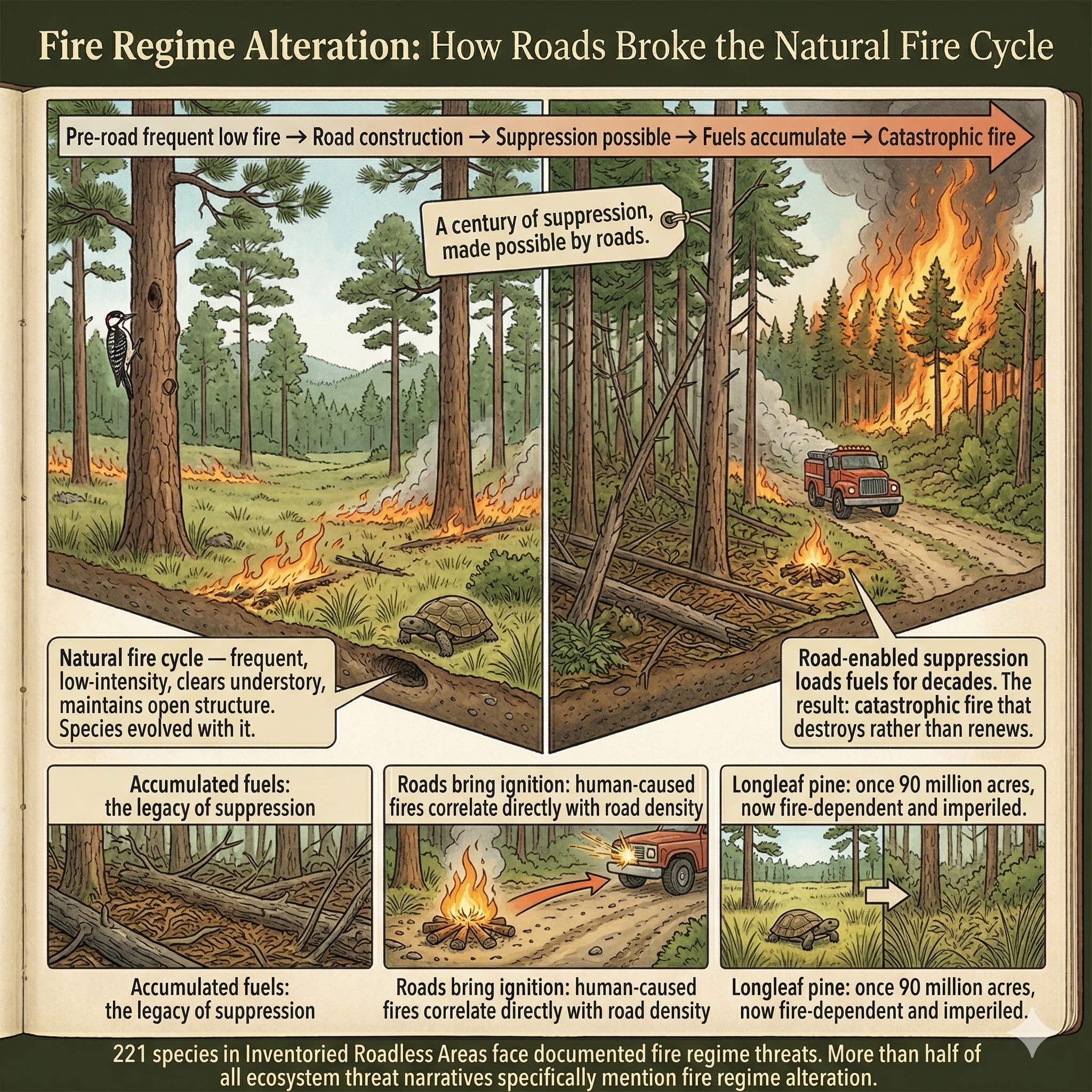
Fire is not the enemy of many North American forests. It is their architect.
The longleaf pine once covered 90 million acres of the American South. It is one of the most biologically rich ecosystems on the continent — home to the Red-cockaded Woodpecker, the Gopher Tortoise, and hundreds of plant species found nowhere else. It evolved with fire so frequent and so reliable — every two to five years across vast stretches of the coastal plain — that it became dependent on it. Without fire, the oaks and other hardwoods that longleaf normally suppresses move in, shade out the wiregrass understory, and the entire community collapses into something that supports a fraction of the species it once did.
The ponderosa pine forests of the West tell the same story. Before European settlement, low-intensity fire moved through these open, parklike woodlands every few years, clearing the understory and preventing the accumulation of the fuel loads that drive catastrophic crown fires. A century of aggressive fire suppression — made possible and economically rational by the road network that allowed fires to be fought — has transformed these landscapes. The fuels have accumulated for decades. The forests that were once resilient to fire are now primed for the kind of catastrophic, stand-replacing fires that kill even the oldest trees and take centuries, not decades, to recover from.
Roads alter fire in two opposing directions simultaneously: they bring suppression capability, and they bring ignition. Human-caused fires — from campfires, equipment sparks, and vehicle exhaust — correlate directly with road density. In a landscape where suppression has already loaded the fuels, the ignition source that roads provide can trigger the catastrophic events that accumulated fuel makes possible.
The official definition of 7.1 Fire & Fire Management covers "management actions that either suppress or increase fire frequency and/or intensity." Its exposition is careful to note that this category "focuses on the human activities that lead to either not enough fire or too much fire in the ecosystem in question" — and that it includes "damaging natural fires in systems that have lost their natural resilience," recognizing that suppression itself creates the conditions for catastrophic fire.
In the roadless areas covered by this application: 221 species carry documented fire regime threats — including 43 critically imperiled and 65 imperiled species. More than half of all ecosystem threat narratives in the database — 124 of 231 — specifically mention fire regime alteration as a documented pressure.
Road access enables aggressive fire suppression that degrades fire-dependent ecosystems. Roads simultaneously increase human-caused ignitions and fragment natural fire behavior. Roadless areas maintain natural fire regimes because suppression access does not exist.
Severity of Impact
NatureServe rates the expected population decline for each species facing this threat, using the IUCN-CMP international standard.
Species at Risk
Imperiled species (G1-G3 or federally listed) with NatureServe-assessed threat records in this category. Sort and filter to explore.
| Species | Rank | ESA | Threat | Severity ▲ | Scope | Areas |
|---|---|---|---|---|---|---|
| Contra Costa Goldfields Lasthenia conjugens | G1 | E | 7.1 Fire & fire suppression | Extreme - moderate | Pervasive - restricted | 6 |
| Giant Kangaroo Rat Dipodomys ingens | G1 | E | 7.1 Fire & fire suppression | Extreme - moderate | Restricted - small | 15 |
| Masked Bobwhite Colinus virginianus ridgwayi | T1 | E | 7.1 Fire & fire suppression | Extreme - moderate | Unknown | 1 |
| Mineral Creek Mountainsnail Oreohelix pilsbryi | G1 | UR | 7.1 Fire & fire suppression | Extreme - moderate | Pervasive (71-100%) | 1 |
| Mt. Graham Red Squirrel Tamiasciurus fremonti grahamensis | T1 | E | 7.1 Fire & fire suppression | Extreme - moderate | Pervasive - restricted | 1 |
| Pinaleno Talussnail Sonorella grahamensis | G1 | 7.1 Fire & fire suppression | Extreme - moderate | Pervasive - large | 1 | |
| Schell Creek Mountainsnail Oreohelix nevadensis | G1 | 7.1 Fire & fire suppression | Extreme - moderate | Restricted (11-30%) | 1 | |
| Applegate's Milkvetch Astragalus applegatei | G1 | E | 7.1 Fire & fire suppression | Extreme - serious | Pervasive (71-100%) | 1 |
| Frosted Flatwoods Salamander Ambystoma cingulatum | G1 | T | 7.1 Fire & fire suppression | Extreme - serious | Pervasive (71-100%) | 4 |
| Jemez Mountains Salamander Plethodon neomexicanus | G1 | E | 7.1 Fire & fire suppression | Extreme - serious | Pervasive (71-100%) | 21 |
| Metcalfe's Bush-beardtongue Penstemon metcalfei | G1 | 7.1 Fire & fire suppression | Extreme - serious | Pervasive - large | 2 | |
| Munz's Onion Allium munzii | G1 | E | 7.1 Fire & fire suppression | Extreme - serious | Pervasive - large | 3 |
| Vail Lake Ceanothus Ceanothus ophiochilus | G1 | T | 7.1 Fire & fire suppression | Extreme - serious | Large (31-70%) | 2 |
| Encinitis Baccharis Baccharis vanessae | G1 | T | 7.1 Fire & fire suppression | Serious or 31-70% pop. decline | Pervasive - large | 2 |
| Mogoll Deathcamas Anticlea mogollonensis | G1 | 7.1.1 Increase in fire frequency/intensity | Serious or 31-70% pop. decline | Pervasive (71-100%) | 1 | |
| Mountain Golden-heather Hudsonia montana | G1 | T | 7.1 Fire & fire suppression | Serious or 31-70% pop. decline | Pervasive (71-100%) | 5 |
| Pawnee Montane Skipper Hesperia leonardus montana | T1 | T | 7.1 Fire & fire suppression | Serious or 31-70% pop. decline | Large (31-70%) | 1 |
| Short's Goldenrod Solidago shortii | G1 | E | 7.1 Fire & fire suppression | Serious or 31-70% pop. decline | Restricted (11-30%) | 1 |
| Kendall Warm Springs Dace Rhinichthys osculus thermalis | T1 | E | 7.1 Fire & fire suppression | Serious - moderate | Pervasive (71-100%) | 5 |
| New Mexico Ridge-nosed Rattlesnake Crotalus willardi obscurus | T1 | T | 7.1 Fire & fire suppression | Serious - moderate | Large - restricted | 1 |
| Pinaleno Mountainsnail Oreohelix grahamensis | G1 | 7.1 Fire & fire suppression | Serious - moderate | Pervasive - restricted | 1 | |
| Agate Desert Lomatium Lomatium cookii | G1 | E | 7.1 Fire & fire suppression | Moderate or 11-30% pop. decline | Large (31-70%) | 1 |
| Buck Creek Ragwort Packera serpenticola | G1 | 7.1.2 Suppression in fire frequency/intensity | Moderate or 11-30% pop. decline | Pervasive (71-100%) | 3 | |
| California Dandelion Taraxacum californicum | G1 | E | 7.1 Fire & fire suppression | Moderate or 11-30% pop. decline | Restricted (11-30%) | 2 |
| Gila Morning Glory Ipomoea gilana | G1 | 7.1 Fire & fire suppression | Moderate or 11-30% pop. decline | Pervasive (71-100%) | 2 | |
| Holy Ghost Ipomopsis Ipomopsis sancti-spiritus | G1 | E | 7.1 Fire & fire suppression | Moderate or 11-30% pop. decline | Pervasive (71-100%) | 14 |
| Laguna Mountains Skipper Pyrgus ruralis lagunae | T1 | E | 7.1 Fire & fire suppression | Moderate or 11-30% pop. decline | Large (31-70%) | 2 |
| Macfarlane's Four-o'clock Mirabilis macfarlanei | G1 | T | 7.1 Fire & fire suppression | Moderate or 11-30% pop. decline | Pervasive - large | 8 |
| Rhiannon's Aster Symphyotrichum rhiannon | G1 | 7.1.2 Suppression in fire frequency/intensity | Moderate or 11-30% pop. decline | Pervasive (71-100%) | 2 | |
| Sacramento Mountains Thistle Cirsium vinaceum | G1 | T | 7.1 Fire & fire suppression | Moderate or 11-30% pop. decline | Large (31-70%) | 7 |
| Wanatchee Mountains Checker-mallow Sidalcea oregana var. calva | T1 | E | 7.1 Fire & fire suppression | Moderate or 11-30% pop. decline | Large (31-70%) | 4 |
| Arroyo Toad Anaxyrus californicus | G1 | E | 7.1 Fire & fire suppression | Moderate - slight | Unknown | 48 |
| Magdalena Mountainsnail Oreohelix magdalenae | G1 | 7.1 Fire & fire suppression | Moderate - slight | Large - restricted | 1 | |
| Noonday Globe Patera nantahala | G1 | T | 7.1 Fire & fire suppression | Moderate - slight | Pervasive - large | 2 |
| Riverside Fairy Shrimp Streptocephalus woottoni | G1 | E | 7.1 Fire & fire suppression | Moderate - slight | Restricted (11-30%) | 22 |
| Santa Monica Mountains Dudleya Dudleya cymosa ssp. ovatifolia | T1 | T | 7.1 Fire & fire suppression | Moderate - slight | Pervasive - restricted | 3 |
| Shale Barren Violet Viola tenuisecta | G1 | 7.1 Fire & fire suppression | Moderate - slight | Large - restricted | 3 | |
| Shasta Crayfish Pacifastacus fortis | G1 | E | 7.1 Fire & fire suppression | Slight or 1-10% pop. decline | Restricted (11-30%) | 4 |
Townsendia lemhiensis | G1 | 7.1.1 Increase in fire frequency/intensity | — | — | 3 | |
| Chupadera Springsnail Pyrgulopsis chupaderae | G1 | E | 7.1 Fire & fire suppression | Unknown | Pervasive - large | 1 |
| Desert Yellowhead Yermo xanthocephalus | G1 | T | 7.1.1 Increase in fire frequency/intensity | Unknown | Unknown | 2 |
| Frank Smith's Violet Viola frank-smithii | G1 | 7.1 Fire & fire suppression | Unknown | Pervasive (71-100%) | 2 | |
| Gray's Lily Lilium grayi | G1 | 7.1.2 Suppression in fire frequency/intensity | Unknown | Unknown | 10 | |
| Independence Valley Speckled Dace Rhinichthys osculus lethoporus | T1 | E | 7.1 Fire & fire suppression | Unknown | Pervasive - restricted | 1 |
| Kelso Creek Monkeyflower Erythranthe shevockii | G1 | 7.1.2 Suppression in fire frequency/intensity | Unknown | Large (31-70%) | 5 | |
| Louisiana Pinesnake Pituophis ruthveni | G1 | T | 7.1 Fire & fire suppression | Unknown | Large - restricted | 2 |
| Nevin's Barberry Berberis nevinii | G1 | E | 7.1 Fire & fire suppression | Unknown | Unknown | 36 |
| Porsild's Starwort Stellaria porsildii | G1 | 7.1 Fire & fire suppression | — | — | 1 | |
| Showy Stickseed Hackelia venusta | G1 | E | 7.1.2 Suppression in fire frequency/intensity | Unknown | Pervasive (71-100%) | 2 |
| Southern Mountain Yellow-legged Frog Rana muscosa | G1 | E | 7.1 Fire & fire suppression | — | — | 55 |
Showing top 50 species. Use filters above to narrow results.
Areas at Risk
Roadless areas where imperiled species face this threat, grouped by state.
Arizona (1)
| Area | Forest | Acres | Species at Risk |
|---|---|---|---|
| Pinaleno | Coronado National Forest | 130,920 | 9 |
California (32)
| Area | Forest | Acres | Species at Risk |
|---|---|---|---|
| Channell | Sequoia National Forest | 45,429 | 12 |
| Chico | Sequoia National Forest | 39,836 | 12 |
| Domeland Add. | Sequoia National Forest | 3,046 | 12 |
| Woodpecker | Sequoia National Forest | 11,936 | 12 |
| Sheep Mountain | Angeles National Forest | 21,098 | 11 |
| Trabuco | Cleveland National Forest | 23,341 | 11 |
| Woolstaff | Sequoia National Forest | 41,445 | 11 |
| Greenhorn Creek | Sequoia National Forest | 28,226 | 10 |
| Sespe - Frazier | Los Padres National Forest | 106,910 | 10 |
| Siskiyou | Klamath National Forest | 54,039 | 10 |
| Strawberry Peak | Angeles National Forest | 7,245 | 10 |
| Wildhorse | Cleveland National Forest | 1,483 | 10 |
| Coldwater | Cleveland National Forest | 8,402 | 9 |
| Cucamonga B | San Bernardino National Forest | 11,933 | 9 |
| Cutca Valley | Cleveland National Forest | 14,530 | 9 |
| Magic Mountain | Angeles National Forest | 15,542 | 9 |
| Mill Creek | Sequoia National Forest | 27,643 | 9 |
| Pleasant View | Angeles National Forest | 26,395 | 9 |
| Rincon | Sequoia National Forest | 54,610 | 9 |
| South Sierra | Inyo National Forest | 41,853 | 9 |
| Cucamonga A | Angeles National Forest | 1,249 | 8 |
| Deep Creek | San Bernardino National Forest | 23,869 | 8 |
| Ladd | Cleveland National Forest | 5,300 | 8 |
| Malduce Buckhorn | Los Padres National Forest | 14,177 | 8 |
| Matilija | Los Padres National Forest | 5,218 | 8 |
| Moses | Sequoia National Forest | 22,077 | 8 |
| Orleans Mtn. | Klamath National Forest | 49,090 | 8 |
| San Dimas | Angeles National Forest | 7,160 | 8 |
| Sawmill - Badlands | Los Padres National Forest | 51,362 | 8 |
| Siskiyou B | Six Rivers National Forest | 18,871 | 8 |
| Slate Mtn. | Sequoia National Forest | 12,299 | 8 |
| South Sierra | Sequoia National Forest | 8,008 | 8 |
Florida (4)
| Area | Forest | Acres | Species at Risk |
|---|---|---|---|
| Savannah | Apalachicola National Forest | 1,927 | 23 |
| Gum Bay | Apalachicola National Forest | 11,645 | 13 |
| Alexander Springs Creek | Ocala National Forest | 2,954 | 11 |
| Long Bay | Apalachicola National Forest | 5,726 | 10 |
Idaho (1)
| Area | Forest | Acres | Species at Risk |
|---|---|---|---|
| Bear Creek | Caribou-Targhee National Forest | 118,582 | 13 |
Nevada (1)
| Area | Forest | Acres | Species at Risk |
|---|---|---|---|
| Pine Grove South | Humboldt-Toiyabe National Forest | 88,945 | 8 |
New Mexico (6)
| Area | Forest | Acres | Species at Risk |
|---|---|---|---|
| Contiguous To Black & Aldo Leopold Wilderness | Gila National Forest | 111,883 | 11 |
| Devils Creek | Gila National Forest | 89,916 | 9 |
| Apache Kid Contiguous | Cibola National Forest | 67,542 | 8 |
| Dry Creek | Gila National Forest | 26,719 | 8 |
| Ryan Hill | Cibola National Forest | 34,201 | 8 |
| Sawyers Peak | Gila National Forest | 59,743 | 8 |
North Carolina (1)
| Area | Forest | Acres | Species at Risk |
|---|---|---|---|
| Harper Creek | Pisgah National Forest | 7,325 | 8 |
Oregon (3)
| Area | Forest | Acres | Species at Risk |
|---|---|---|---|
| South Kalmiopsis | Siskiyou National Forests | 104,477 | 9 |
| Maiden Peak | Willamette National Forest | 9,627 | 8 |
| Maiden Peak | Deschutes National Forest | 26,432 | 8 |
South Dakota (1)
| Area | Forest | Acres | Species at Risk |
|---|---|---|---|
| Indian Creek | Buffalo Gap National Grassland | 24,666 | 22 |
IUCN Threat Classification
Official definitions from the IUCN-CMP Unified Classification of Direct Threats.
7.1 — Fire & Fire Management (v4.0)
Co-occurring Threats
Roads rarely cause a single type of harm. This threat frequently co-occurs with:
Data Sources
- NatureServe Explorer: species threat assessments using IUCN-CMP v3.2
- IUCN-CMP Threat Category 7.1
- NatureServe ecosystem threat narratives and dynamics descriptions
- IUCN-CMP v4.0: Salafsky et al., Conservation Biology, 2025
Fire Regime Alteration