Aquatic Passage & Hydrological Connectivity
Road stream crossings — culverts and bridges — are the most pervasive barrier to fish passage in national forests. Roadless areas have none.
The Threat
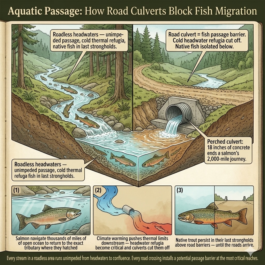
A salmon does not choose its stream at random. It returns, with uncanny precision, to the tributary where it hatched — navigating thousands of miles of open ocean to find the specific gravel bar where its life began. That navigation is encoded in its body. What is not encoded is any ability to pass through a culvert installed at a road crossing that sits eighteen inches above the water's surface, or through a pipe too narrow for its body, or over a concrete headwall with no pool below to rest in.
Road stream crossings — culverts and bridges — are the most pervasive barrier to fish passage in national forests. They are, in hydrological terms, small dams: structures that interrupt the continuity of stream channels, block the upstream movement of fish, and alter the flow regimes on which aquatic ecosystems depend. The absence of roads in roadless areas means the absence of these crossings. Every stream in a roadless area runs unimpeded from its headwaters to its confluence with a roaded stream below.
That connectivity is not incidental. Headwater streams in roadless areas are the cold-water refugia that many salmonid species increasingly depend on as climate warming pushes thermal limits downstream. They are the spawning grounds that sustain the fish populations in the larger rivers below. They are the reaches where native brook trout, bull trout, cutthroat, and steelhead persist in their last strongholds, above the passage barriers and the introduced species and the warmer, more degraded water that roads have brought to the drainages below them.
Road construction in roadless areas means culverts in those headwater streams. It means fish passage barriers at the very reaches where passage matters most. It means that the thermal refugia that climate change makes increasingly critical become isolated from the population reservoirs that would otherwise recolonize them as conditions change.
The official definition of 7.2 Dams & Water Management / Use covers "management actions that modify water levels, flows, and chemistry." The exposition notes that this category "focuses on the human activities that alter or fragment aquatic habitats, alter water flows and chemistry." A culvert that blocks fish passage is, functionally, exactly this — a structure that fragments aquatic habitat and alters the flow regime of the channel it crosses.
In the roadless areas covered by this application: 253 species carry documented aquatic passage and hydrological connectivity threats across 1,238 areas — including 105 critically imperiled (G1/T1) species and 164 federally listed species. This threat is entirely road-dependent: every species count in this category represents an organism whose habitat connectivity would be directly degraded by the stream crossings that road construction installs.
This threat is entirely dependent on road construction. No roads means no stream crossings. No stream crossings means no passage barriers. The hydrological connectivity of roadless streams is a direct function of their roadless condition.
Severity of Impact
NatureServe rates the expected population decline for each species facing this threat, using the IUCN-CMP international standard.
Species at Risk
Imperiled species (G1-G3 or federally listed) with NatureServe-assessed threat records in this category. Sort and filter to explore.
| Species | Rank | ESA | Threat | Severity ▲ | Scope | Areas |
|---|---|---|---|---|---|---|
| Amber Darter Percina antesella | G1 | E | 7.2 Dams & water management/use | Extreme or 71-100% pop. decline | Unknown | 4 |
| Bonytail Gila elegans | G1 | E | 7.2 Dams & water management/use | Extreme or 71-100% pop. decline | Pervasive (71-100%) | 99 |
| Bruneau Hot Springsnail Pyrgulopsis bruneauensis | G1 | E | 7.2 Dams & water management/use | Extreme or 71-100% pop. decline | Pervasive (71-100%) | 22 |
| Chihuahua Chub Gila nigrescens | G1 | T | 7.2 Dams & water management/use | Extreme - moderate | Pervasive - restricted | 3 |
| Chipola Slabshell Elliptio chipolaensis | G1 | T, PDL | 7.2 Dams & water management/use | Extreme or 71-100% pop. decline | Pervasive - large | 1 |
| Clover Valley Speckled Dace Rhinichthys osculus oligoporus | T1 | E | 7.2 Dams & water management/use | Extreme - moderate | Pervasive - restricted | 11 |
| Conasauga Logperch Percina jenkinsi | G1 | E | 7.2 Dams & water management/use | Extreme - moderate | Pervasive - large | 3 |
| Contra Costa Goldfields Lasthenia conjugens | G1 | E | 7.2 Dams & water management/use | Extreme - moderate | Pervasive - restricted | 6 |
| Cui-ui Chasmistes cujus | G1 | E | 7.2 Dams & water management/use | Extreme - moderate | Pervasive (71-100%) | 15 |
| Desert Dace Eremichthys acros | G1 | T | 7.2 Dams & water management/use | Extreme - moderate | Pervasive - large | 1 |
| Desert Pupfish Cyprinodon macularius | G1 | E | 7.2 Dams & water management/use | Extreme - moderate | Unknown | 8 |
| Devil's Hole Pupfish Cyprinodon diabolis | G1 | E | 7.2 Dams & water management/use | Extreme - moderate | Pervasive (71-100%) | 15 |
| Dixie Valley Toad Anaxyrus williamsi | G1 | E | 7.2 Dams & water management/use | Extreme or 71-100% pop. decline | Pervasive (71-100%) | 1 |
| Duskytail Darter Etheostoma percnurum | G1 | 7.2 Dams & water management/use | Extreme - moderate | Restricted (11-30%) | 4 | |
| Fish Slough Milkvetch Astragalus lentiginosus var. piscinensis | T1 | T | 7.2 Dams & water management/use | Extreme or 71-100% pop. decline | Large (31-70%) | 3 |
| Applegate's Milkvetch Astragalus applegatei | G1 | E | 7.2 Dams & water management/use | Extreme - serious | Pervasive (71-100%) | 1 |
| Banbury Springs Limpet Idaholanx fresti | G1 | E | 7.2 Dams & water management/use | Extreme - serious | Large (31-70%) | 1 |
| Burke's Goldfields Lasthenia burkei | G1 | E | 7.2 Dams & water management/use | Extreme - serious | Pervasive - large | 7 |
| Chupadera Springsnail Pyrgulopsis chupaderae | G1 | E | 7.2 Dams & water management/use | Extreme - serious | Pervasive (71-100%) | 1 |
| Colorado Pikeminnow Ptychocheilus lucius | G1 | E, XN | 7.2 Dams & water management/use | Extreme - serious | Pervasive (71-100%) | 99 |
| Cracking Pearlymussel Hemistena lata | G1 | E, XN | 7.2 Dams & water management/use | Extreme - serious | Restricted (11-30%) | 1 |
| Cushenbury Buckwheat Eriogonum ovalifolium var. vineum | T1 | E | 7.2 Dams & water management/use | Extreme - serious | Pervasive - large | 2 |
| Fanshell Cyprogenia stegaria | G1 | E, XN | 7.2 Dams & water management/use | Extreme - serious | Large (31-70%) | 3 |
| Florida Torreya Torreya taxifolia | G1 | E | 7.2 Dams & water management/use | Extreme - serious | Pervasive - large | 1 |
| Humpback Chub Gila cypha | G1 | T | 7.2 Dams & water management/use | Extreme - serious | Pervasive (71-100%) | 99 |
| James Spinymussel Parvaspina collina | G1 | E | 7.2 Dams & water management/use | Extreme - serious | Large (31-70%) | 16 |
| Anthony's Riversnail Athearnia anthonyi | G1 | E, XN | 7.2 Dams & water management/use | Serious or 31-70% pop. decline | Large (31-70%) | 6 |
| Appalachian Elktoe Alasmidonta raveneliana | G1 | E | 7.2.11 Dams (size unknown) | Serious or 31-70% pop. decline | Pervasive (71-100%) | 1 |
| Appalachian Rockshell Theliderma sparsa | G1 | E, XN | 7.2 Dams & water management/use | Serious or 31-70% pop. decline | Large (31-70%) | 1 |
| Arroyo Chub Gila orcuttii | G1 | 7.2 Dams & water management/use | Serious or 31-70% pop. decline | Large (31-70%) | 13 | |
| Atlantic Pigtoe Fusconaia masoni | G1 | T | 7.2 Dams & water management/use | Serious or 31-70% pop. decline | Large (31-70%) | 4 |
| Bleached Sandhill Skipper Polites sabuleti sinemaculata | T1 | PE | 7.2 Dams & water management/use | Serious or 31-70% pop. decline | Large (31-70%) | 1 |
| California Dandelion Taraxacum californicum | G1 | E | 7.2 Dams & water management/use | Serious or 31-70% pop. decline | Pervasive (71-100%) | 2 |
| Coosa Moccasinshell Medionidus parvulus | G1 | E | 7.2 Dams & water management/use | Serious or 31-70% pop. decline | Large (31-70%) | 5 |
| Cumberlandian Combshell Epioblasma brevidens | G1 | E, XN | 7.2 Dams & water management/use | Serious or 31-70% pop. decline | Large (31-70%) | 1 |
| Dromedary Pearlymussel Dromus dromas | G1 | E, XN | 7.2 Dams & water management/use | Serious or 31-70% pop. decline | Large (31-70%) | 1 |
| Fat Threeridge Amblema neislerii | G1 | E, PDL | 7.2 Dams & water management/use | Serious or 31-70% pop. decline | Small (1-10%) | 1 |
| Finerayed Pigtoe Fusconaia cuneolus | G1 | E, XN | 7.2 Dams & water management/use | Serious or 31-70% pop. decline | Large (31-70%) | 6 |
| Georgia Pigtoe Pleurobema hanleyianum | G1 | E | 7.2 Dams & water management/use | Serious or 31-70% pop. decline | Large (31-70%) | 3 |
| Clubshell Pleurobema clava | G1 | E, XN | 7.2 Dams & water management/use | Serious - moderate | Large - restricted | 2 |
| Hiko White River Springfish Crenichthys baileyi grandis | T1 | E | 7.2 Dams & water management/use | Serious - slight | Large (31-70%) | 17 |
| Cumberland Rockshell Theliderma intermedia | G1 | E, XN | 7.2 Dams & water management/use | Moderate or 11-30% pop. decline | Restricted (11-30%) | 1 |
| Arroyo Toad Anaxyrus californicus | G1 | E | 7.2 Dams & water management/use | Moderate - slight | Large (31-70%) | 48 |
| Benton County Cave Crayfish Cambarus aculabrum | G1 | E | 7.2 Dams & water management/use | Moderate - slight | Small (1-10%) | 1 |
| Bliss Rapids Snail Taylorconcha serpenticola | G1 | T | 7.2 Dams & water management/use | Moderate - slight | Large - restricted | 1 |
| Clay-loving Wild Buckwheat Eriogonum pelinophilum | G1 | E | 7.2 Dams & water management/use | Slight or 1-10% pop. decline | Large (31-70%) | 1 |
| Bear Valley Sandwort Eremogone ursina | G1 | T | 7.2 Dams & water management/use | Unknown | Unknown | 2 |
| Black Toad Anaxyrus exsul | G1 | 7.2 Dams & water management/use | — | — | 5 | |
| Carson Wandering Skipper Pseudocopaeodes eunus obscurus | T1 | E | 7.2 Dams & water management/use | Unknown | Pervasive - large | 7 |
| Independence Valley Speckled Dace Rhinichthys osculus lethoporus | T1 | E | 7.2 Dams & water management/use | Unknown | Pervasive (71-100%) | 1 |
Showing top 50 species. Use filters above to narrow results.
Areas at Risk
Roadless areas where imperiled species face this threat, grouped by state.
Alabama (2)
| Area | Forest | Acres | Species at Risk |
|---|---|---|---|
| Blue Mountain | Talladega National Forest | 4,986 | 8 |
| Cheaha A | Talladega National Forest | 236 | 8 |
Arizona (9)
| Area | Forest | Acres | Species at Risk |
|---|---|---|---|
| Galiuro | Coronado National Forest | 28,333 | 12 |
| Tumacacori | Coronado National Forest | 44,594 | 11 |
| Butterfly Roadless Area | Coronado National Forest | 42,296 | 10 |
| Lower San Francisco | Apache-Sitgreaves National Forests | 59,310 | 10 |
| Mazatzal | Tonto National Forest | 16,942 | 10 |
| Chiricahua | Coronado National Forest | 76,876 | 9 |
| Hackberry | Coconino National Forest | 17,885 | 9 |
| Happy Valley | Coronado National Forest | 7,972 | 9 |
| Upper Rincon Roadless | Coronado National Forest | 2,991 | 9 |
California (16)
| Area | Forest | Acres | Species at Risk |
|---|---|---|---|
| Sespe - Frazier | Los Padres National Forest | 106,910 | 12 |
| Magic Mountain | Angeles National Forest | 15,542 | 10 |
| Matilija | Los Padres National Forest | 5,218 | 10 |
| White Ledge | Los Padres National Forest | 18,632 | 10 |
| Antimony | Los Padres National Forest | 40,911 | 9 |
| Dry Lakes | Los Padres National Forest | 17,043 | 9 |
| Fish Canyon | Angeles National Forest | 29,886 | 9 |
| La Brea | Los Padres National Forest | 14,031 | 9 |
| Nordhoff | Los Padres National Forest | 12,031 | 9 |
| Red Mountain | Angeles National Forest | 8,034 | 9 |
| Salt Creek | Angeles National Forest | 11,022 | 9 |
| Sawmill - Badlands | Los Padres National Forest | 51,362 | 9 |
| Big Rocks | Los Padres National Forest | 11,866 | 8 |
| Cajon | San Bernardino National Forest | 7,548 | 8 |
| Fox Mountain | Los Padres National Forest | 52,072 | 8 |
| Garcia Mountain | Los Padres National Forest | 7,850 | 8 |
Colorado (1)
| Area | Forest | Acres | Species at Risk |
|---|---|---|---|
| Dome Peak | Routt NF | 35,716 | 8 |
Florida (1)
| Area | Forest | Acres | Species at Risk |
|---|---|---|---|
| Savannah | Apalachicola National Forest | 1,927 | 10 |
Georgia (4)
| Area | Forest | Acres | Species at Risk |
|---|---|---|---|
| Pink Knob | Chattahoochee National Forest | 12,127 | 17 |
| Ken Mountain | Chattahoochee National Forest | 527 | 14 |
| Foster Branch | Chattahoochee National Forest | 171 | 12 |
| Lance Creek | Chattahoochee National Forest | 9,025 | 9 |
Idaho (1)
| Area | Forest | Acres | Species at Risk |
|---|---|---|---|
| Bear Creek | Caribou-Targhee National Forest | 118,582 | 45 |
Illinois (1)
| Area | Forest | Acres | Species at Risk |
|---|---|---|---|
| Burke Branch | Shawnee National Forest | 6,231 | 9 |
New Mexico (1)
| Area | Forest | Acres | Species at Risk |
|---|---|---|---|
| Lower San Francisco | Gila National Forest | 26,460 | 9 |
North Carolina (1)
| Area | Forest | Acres | Species at Risk |
|---|---|---|---|
| Snowbird | Nantahala National Forest | 8,489 | 10 |
South Dakota (1)
| Area | Forest | Acres | Species at Risk |
|---|---|---|---|
| Indian Creek | Buffalo Gap National Grassland | 24,666 | 45 |
Tennessee (6)
| Area | Forest | Acres | Species at Risk |
|---|---|---|---|
| Brushy Ridge | Cherokee National Forest | 7,469 | 13 |
| Upper Bald River | Cherokee National Forest | 9,202 | 13 |
| Bald River Gorge Addition | Cherokee National Forest | 1,728 | 10 |
| Little Frog Addition NE | Cherokee National Forest | 321 | 9 |
| Little Frog Addition NW | Cherokee National Forest | 628 | 9 |
| Sycamore Creek | Cherokee National Forest | 6,984 | 9 |
Texas (1)
| Area | Forest | Acres | Species at Risk |
|---|---|---|---|
| Big Creek | National Forests in Texas | 1,447 | 15 |
Virginia (5)
| Area | Forest | Acres | Species at Risk |
|---|---|---|---|
| Bear Creek | Jefferson National Forest | 18,274 | 11 |
| Hunting Camp Little Wolf Creek | Jefferson National Forest | 8,953 | 11 |
| Beartown Addition A | Jefferson National Forest | 1,370 | 9 |
| Beartown Addition B | Jefferson National Forest | 2,985 | 9 |
| Garden Mountain | Jefferson National Forest | 3,960 | 9 |
IUCN Threat Classification
Official definitions from the IUCN-CMP Unified Classification of Direct Threats.
7.2 — Dams & Water Management / Use (v4.0)
Co-occurring Threats
Roads rarely cause a single type of harm. This threat frequently co-occurs with:
Data Sources
- NatureServe Explorer: species threat assessments using IUCN-CMP v3.2
- IUCN-CMP Threat Category 7.2
- IUCN-CMP v4.0: Salafsky et al., Conservation Biology, 2025
Aquatic Passage & Hydrological Connectivity