Climate Change & Refugia Function
Roadless areas function as climate refugia — intact forest, cold headwater streams, and unbroken elevation gradients buffer species against warming. Road construction degrades all of these functions.
The Threat
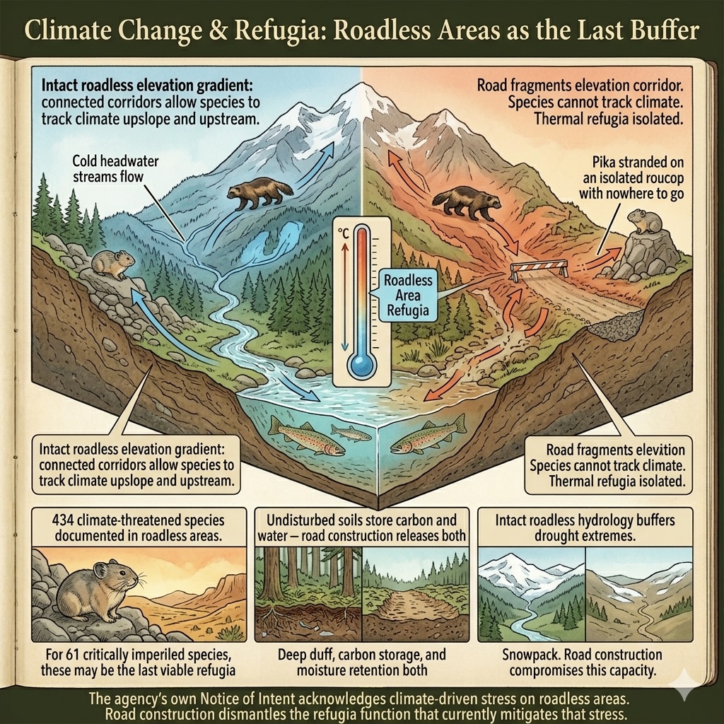
The Notice of Intent that initiated this rulemaking acknowledges, in its own language, "growing impacts of extreme wildfire, drought, and insect and disease infestations" within Inventoried Roadless Areas. The agency cites these as justifications for rescission — arguments for more active management. What the NOI does not acknowledge is that the roadless condition itself is one of the primary defenses these landscapes have against the climate-driven stresses the agency names.
Climate change is not a future threat to roadless areas. It is a present one. Species ranges are shifting. Snowpack is declining. Fire seasons are lengthening. Drought cycles are intensifying. Aquatic thermal regimes are warming. The species and ecosystems documented in this database are not facing these pressures in isolation — they are facing them in landscapes where the only remaining buffer is the ecological integrity that the roadless condition preserves.
Roadless areas function as climate refugia in specific, documentable ways. Their intact forest cover moderates ground-level temperature, maintaining cooler and more stable microclimate conditions than the adjacent managed forest. Their unroaded headwater streams remain cold longer as regional temperatures rise, providing thermal refugia for cold-water fish species as lowland and mid-elevation reaches become inhospitable. Their elevation gradients — unbroken by roads — provide the movement corridors that allow species to track suitable climate conditions upslope and upstream. Their undisturbed soils store carbon and water in ways that buffered, managed landscapes cannot.
Road construction degrades all of these refugia functions simultaneously. Canopy disruption warms the microclimate. Sediment loads warm and cloud streams. Fragmentation severs the elevation corridors along which species migrate. The carbon stored in undisturbed forest soils is released. The hydrological buffering capacity of intact duff and root systems is compromised.
The DEIS Comment Template documents 434 climate-threatened species — carrying NatureServe threat codes in category 11 — present in roadless areas. These are species for which professional ecologists have already assessed climate change as a documented, ongoing threat to their populations. For 61 of these species — those rated G1-G3 or T1-T3, facing a very high or high risk of extinction — the roadless area they inhabit may be among the last places on the landscape where their climate adaptation needs can be met.
The IUCN classification's three climate subcodes — 11.1 Changes in Physical & Chemical Regimes, 11.2 Changes in Temperature Regimes, and 11.3 Changes in Precipitation & Hydrological Regimes — together capture the suite of climate-driven pressures that roadless areas are currently buffering against. Road construction does not cause climate change. But it dismantles the last defenses that roadless terrain provides against it.
In the roadless areas covered by this application: 288 species carry documented climate-related threats (IUCN category 11) across 2,036 areas — including 99 critically imperiled (G1/T1) species and 138 federally listed species. These are species for which professional ecologists have already assessed climate change as a documented, ongoing threat — and for which the intact roadless condition provides the refugia function that makes survival possible.
The agency's own NOI acknowledges climate-driven stresses on these landscapes. Road construction degrades the refugia function — intact canopy, cold headwater streams, unbroken elevation corridors — that currently mitigates those stresses.
Severity of Impact
NatureServe rates the expected population decline for each species facing this threat, using the IUCN-CMP international standard.
Species at Risk
Imperiled species (G1-G3 or federally listed) with NatureServe-assessed threat records in this category. Sort and filter to explore.
| Species | Rank | ESA | Threat | Severity ▲ | Scope | Areas |
|---|---|---|---|---|---|---|
| Banbury Springs Limpet Idaholanx fresti | G1 | E | 11.3 Temperature extremes | Extreme - moderate | Pervasive (71-100%) | 1 |
| Chupadera Springsnail Pyrgulopsis chupaderae | G1 | E | 11.2 Droughts | Extreme - moderate | Pervasive (71-100%) | 1 |
| Cushion Bladderpod Physaria pulvinata | G1 | 11.2 Droughts | Extreme - moderate | Pervasive (71-100%) | 1 | |
| Independence Valley Speckled Dace Rhinichthys osculus lethoporus | T1 | E | 11.2 Droughts | Extreme - moderate | Pervasive (71-100%) | 1 |
| Kendall Warm Springs Dace Rhinichthys osculus thermalis | T1 | E | 11.2 Droughts | Extreme - moderate | Pervasive (71-100%) | 5 |
| Little Colorado Spinedace Lepidomeda vittata | G1 | T | 11.2 Droughts | Extreme - moderate | Pervasive (71-100%) | 3 |
| Louisiana Pigtoe Pleurobema riddellii | G1 | PT | 11.2 Droughts | Extreme or 71-100% pop. decline | Pervasive (71-100%) | 3 |
| New Mexico Ridge-nosed Rattlesnake Crotalus willardi obscurus | T1 | T | 11.1 Habitat shifting & alteration | Extreme or 71-100% pop. decline | Pervasive (71-100%) | 1 |
| Clay Phacelia Phacelia argillacea | G1 | E | 11.2 Droughts | Extreme - serious | Pervasive (71-100%) | 11 |
| Contra Costa Goldfields Lasthenia conjugens | G1 | E | 11.2 Droughts | Extreme - serious | Pervasive - restricted | 6 |
| Kremmling Beardtongue Penstemon penlandii | G1 | E | 11.2 Droughts | Extreme - serious | Pervasive (71-100%) | 3 |
| Mt. Graham Red Squirrel Tamiasciurus fremonti grahamensis | T1 | E | 11.1 Habitat shifting & alteration | Extreme - serious | Pervasive (71-100%) | 1 |
| Bleached Sandhill Skipper Polites sabuleti sinemaculata | T1 | PE | 11.1 Habitat shifting & alteration | Serious or 31-70% pop. decline | Pervasive (71-100%) | 1 |
| Clay-loving Wild Buckwheat Eriogonum pelinophilum | G1 | E | 11.2 Droughts | Serious or 31-70% pop. decline | Pervasive (71-100%) | 1 |
| Cumberlandian Combshell Epioblasma brevidens | G1 | E, XN | 11.2 Droughts | Serious or 31-70% pop. decline | Restricted (11-30%) | 1 |
| Eastern Black Rail Laterallus jamaicensis jamaicensis | T1 | T | 11.2 Droughts | Serious or 31-70% pop. decline | Large (31-70%) | 29 |
| Encinitis Baccharis Baccharis vanessae | G1 | T | 11.2 Droughts | Serious or 31-70% pop. decline | Pervasive - large | 2 |
| Neches River Rosemallow Hibiscus dasycalyx | G1 | T | 11.2 Droughts | Serious or 31-70% pop. decline | Large (31-70%) | 1 |
| Appalachian Elktoe Alasmidonta raveneliana | G1 | E | 11.2 Droughts | Serious - moderate | Restricted (11-30%) | 1 |
| Chiricahua Talussnail Sonorella virilis | G1 | 11.1 Habitat shifting & alteration | Serious - moderate | Pervasive - large | 1 | |
| Fat Threeridge Amblema neislerii | G1 | E, PDL | 11.1 Habitat shifting & alteration | Serious - moderate | Pervasive (71-100%) | 1 |
| Masked Bobwhite Colinus virginianus ridgwayi | T1 | E | 11.2 Droughts | Serious - moderate | Pervasive (71-100%) | 1 |
| Arroyo Toad Anaxyrus californicus | G1 | E | 11.2 Droughts | Moderate or 11-30% pop. decline | Pervasive (71-100%) | 48 |
| Barneby's Clover Trifolium barnebyi | G1 | 11.2 Droughts | Moderate or 11-30% pop. decline | Pervasive (71-100%) | 1 | |
| Clubshell Pleurobema clava | G1 | E, XN | 11.1 Habitat shifting & alteration | Moderate or 11-30% pop. decline | Large (31-70%) | 2 |
| Coosa Moccasinshell Medionidus parvulus | G1 | E | 11.1 Habitat shifting & alteration | Moderate or 11-30% pop. decline | Large - restricted | 5 |
| Georgia Pigtoe Pleurobema hanleyianum | G1 | E | 11.1 Habitat shifting & alteration | Moderate or 11-30% pop. decline | Large (31-70%) | 3 |
| Gila Morning Glory Ipomoea gilana | G1 | 11.2 Droughts | Moderate or 11-30% pop. decline | Pervasive (71-100%) | 2 | |
| Green's Awnless Orcutt Grass Tuctoria greenei | G1 | E | 11.1 Habitat shifting & alteration | Moderate or 11-30% pop. decline | Large - restricted | 24 |
| Hawaiian Petrel Pterodroma sandwichensis | G1 | E | 11.1 Habitat shifting & alteration | Moderate or 11-30% pop. decline | Pervasive (71-100%) | 4 |
| Holy Ghost Ipomopsis Ipomopsis sancti-spiritus | G1 | E | 11.2 Droughts | Moderate or 11-30% pop. decline | Pervasive (71-100%) | 14 |
| Laguna Mountains Skipper Pyrgus ruralis lagunae | T1 | E | 11.2 Droughts | Moderate or 11-30% pop. decline | Pervasive (71-100%) | 2 |
| Littlewing Pearlymussel Pegias fabula | G1 | E | 11.1 Habitat shifting & alteration | Moderate or 11-30% pop. decline | Large - restricted | 1 |
| Benton County Cave Crayfish Cambarus aculabrum | G1 | E | 11.3 Temperature extremes | Moderate - slight | Pervasive - restricted | 1 |
| Blunt-nosed Leopard Lizard Gambelia sila | G1 | E | 11.2 Droughts | Moderate - slight | Pervasive (71-100%) | 1 |
| Noonday Globe Patera nantahala | G1 | T | 11.2 Droughts | Moderate - slight | Large - restricted | 2 |
| Arroyo Chub Gila orcuttii | G1 | 11.1 Habitat shifting & alteration | Slight or 1-10% pop. decline | Pervasive (71-100%) | 13 | |
Townsendia lemhiensis | G1 | 11.1 Habitat shifting & alteration | — | — | 3 | |
| Big Spring Legless Lizard Anniella campi | G1 | 11.2 Droughts | Unknown | Pervasive (71-100%) | 2 | |
| Carson Wandering Skipper Pseudocopaeodes eunus obscurus | T1 | E | 11.1 Habitat shifting & alteration | Unknown | Unknown | 7 |
| Colorado Pikeminnow Ptychocheilus lucius | G1 | E, XN | 11.1 Habitat shifting & alteration | — | — | 99 |
| Cronquist's Woody-aster Xylorhiza cronquistii | G1 | 11.2 Droughts | Unknown | Pervasive (71-100%) | 1 | |
| Desert Yellowhead Yermo xanthocephalus | G1 | T | 11.2 Droughts | Unknown | Pervasive (71-100%) | 2 |
| Dromedary Pearlymussel Dromus dromas | G1 | E, XN | 11.1 Habitat shifting & alteration | Unknown | Large (31-70%) | 1 |
| Great Lakes Jacob's-ladder Polemonium lacustre | G1 | 11.2 Droughts | Unknown | Pervasive (71-100%) | 1 | |
| Harrison's Thistle Cirsium harrisonii | G1 | 11.2 Droughts | Unknown | Pervasive (71-100%) | 2 | |
| Holmgren's Buckwheat Eriogonum holmgrenii | G1 | 11.1 Habitat shifting & alteration | — | — | 4 | |
| Lassicus Lupine Lupinus constancei | G1 | E | 11.1 Habitat shifting & alteration | — | — | 3 |
| Maguire's Primrose Primula maguirei | G1 | T | 11.2 Droughts | Unknown | Pervasive (71-100%) | 9 |
| Monte Neva Indian-paintbrush Castilleja salsuginosa | G1 | 11.2 Droughts | Unknown | Pervasive (71-100%) | 1 |
Showing top 50 species. Use filters above to narrow results.
Areas at Risk
Roadless areas where imperiled species face this threat, grouped by state.
Alabama (2)
| Area | Forest | Acres | Species at Risk |
|---|---|---|---|
| Cheaha A | Talladega National Forest | 236 | 10 |
| Oakey Mountain | Talladega National Forest | 6,129 | 9 |
Arizona (6)
| Area | Forest | Acres | Species at Risk |
|---|---|---|---|
| Tumacacori | Coronado National Forest | 44,594 | 12 |
| Mazatzal | Tonto National Forest | 16,942 | 10 |
| Butterfly Roadless Area | Coronado National Forest | 42,296 | 9 |
| Chiricahua | Coronado National Forest | 76,876 | 9 |
| Happy Valley | Coronado National Forest | 7,972 | 9 |
| Lower San Francisco | Apache-Sitgreaves National Forests | 59,310 | 9 |
California (12)
| Area | Forest | Acres | Species at Risk |
|---|---|---|---|
| Sespe - Frazier | Los Padres National Forest | 106,910 | 11 |
| Tom Martin | Klamath National Forest | 9,031 | 11 |
| Little French C | Shasta-Trinity National Forest | 11,529 | 10 |
| Siskiyou | Klamath National Forest | 54,039 | 10 |
| White Ledge | Los Padres National Forest | 18,632 | 10 |
| Coyote Southeast | Inyo National Forest | 53,159 | 9 |
| Domeland Add. | Sequoia National Forest | 3,046 | 9 |
| Juncal | Los Padres National Forest | 12,289 | 9 |
| Kangaroo | Klamath National Forest | 40,617 | 9 |
| Matilija | Los Padres National Forest | 5,218 | 9 |
| Orleans Mtn. | Klamath National Forest | 49,090 | 9 |
| Rincon | Sequoia National Forest | 54,610 | 9 |
Colorado (2)
| Area | Forest | Acres | Species at Risk |
|---|---|---|---|
| Comanche Peak Adjacent Area | Arapaho & Roosevelt NFs | 44,158 | 9 |
| Dome Peak | Routt NF | 35,716 | 9 |
Florida (1)
| Area | Forest | Acres | Species at Risk |
|---|---|---|---|
| Savannah | Apalachicola National Forest | 1,927 | 9 |
Georgia (3)
| Area | Forest | Acres | Species at Risk |
|---|---|---|---|
| Pink Knob | Chattahoochee National Forest | 12,127 | 13 |
| Ken Mountain | Chattahoochee National Forest | 527 | 10 |
| Foster Branch | Chattahoochee National Forest | 171 | 9 |
Idaho (1)
| Area | Forest | Acres | Species at Risk |
|---|---|---|---|
| Bear Creek | Caribou-Targhee National Forest | 118,582 | 28 |
New Mexico (11)
| Area | Forest | Acres | Species at Risk |
|---|---|---|---|
| Contiguous To Black & Aldo Leopold Wilderness | Gila National Forest | 111,883 | 11 |
| Apache Kid Contiguous | Cibola National Forest | 67,542 | 10 |
| Contiguous To Gila Wilderness & Primitive Area | Gila National Forest | 79,049 | 9 |
| Devils Creek | Gila National Forest | 89,916 | 9 |
| Dry Creek | Gila National Forest | 26,719 | 9 |
| Elk Mountain | Gila National Forest | 6,550 | 9 |
| Frisco Box | Gila National Forest | 38,979 | 9 |
| Lower San Francisco | Gila National Forest | 26,460 | 9 |
| Meadow Creek | Gila National Forest | 34,167 | 9 |
| Peloncillo (NM) | Coronado National Forest | 43,339 | 9 |
| Ryan Hill | Cibola National Forest | 34,201 | 9 |
North Carolina (3)
| Area | Forest | Acres | Species at Risk |
|---|---|---|---|
| Graveyard Ridge (addition) | Pisgah National Forest | 1,958 | 9 |
| Harper Creek | Pisgah National Forest | 7,325 | 9 |
| Lost Cove | Pisgah National Forest | 5,944 | 9 |
Oklahoma (1)
| Area | Forest | Acres | Species at Risk |
|---|---|---|---|
| Beech Creek | Ouachita National Forest | 8,303 | 9 |
South Dakota (1)
| Area | Forest | Acres | Species at Risk |
|---|---|---|---|
| Indian Creek | Buffalo Gap National Grassland | 24,666 | 51 |
Texas (1)
| Area | Forest | Acres | Species at Risk |
|---|---|---|---|
| Big Creek | National Forests in Texas | 1,447 | 17 |
Utah (6)
| Area | Forest | Acres | Species at Risk |
|---|---|---|---|
| Casto Bluff | Dixie National Forest | 87,466 | 11 |
| 0419020 | Ashley National Forest | 355,684 | 10 |
| Pine Valley Mountains | Dixie National Forest | 57,673 | 10 |
| Boulder Mtn. / Boulder Top / Deer Lake | Dixie National Forest | 110,690 | 9 |
| Long Neck Mesa / Steep Creek / Oak Creek - Steep Creek / Oak | Dixie National Forest | 55,489 | 9 |
| Lookout Peak | Fishlake National Forest | 9,195 | 9 |
IUCN Threat Classification
Official definitions from the IUCN-CMP Unified Classification of Direct Threats.
11.1 — Changes in Physical & Chemical Regimes (v4.0)
11.2 — Changes in Temperature Regimes (v4.0)
11.3 — Changes in Precipitation & Hydrological Regimes (v4.0)
Co-occurring Threats
Roads rarely cause a single type of harm. This threat frequently co-occurs with:
Data Sources
- NatureServe Explorer: species threat assessments using IUCN-CMP v3.2
- IUCN-CMP Threat Categories 11.1, 11.2, 11.3
- IUCN-CMP v4.0: Salafsky et al., Conservation Biology, 2025
Climate Change & Refugia Function