Extractive Industries — Mining & Energy
The proposed rescission responds to executive orders declaring that energy and mineral production must be facilitated on public lands.
The Threat
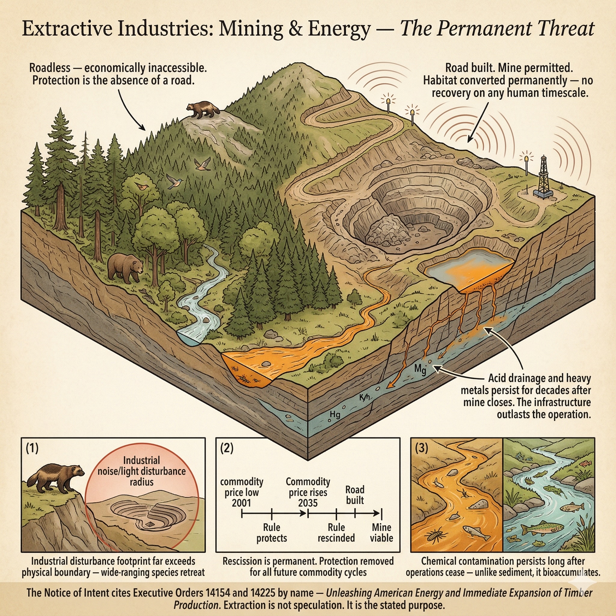
The Notice of Intent that launched this rulemaking does not hide its purpose. The proposed rescission is explicitly grounded in Executive Order 14154, Unleashing American Energy, and Executive Order 14225, Immediate Expansion of American Timber Production — orders declaring that domestic energy, mineral, and timber resources must be produced "to the maximum possible extent" on federal lands. The agency's own words put resource extraction squarely within the foreseeable consequences of rescinding the Roadless Rule. A DEIS that does not fully analyze those consequences fails the legal standard it is required to meet.
Mining and energy extraction bring everything that logging roads bring — invasive species vectors, sedimentation, habitat fragmentation — and several things logging does not.
Permanent conversion. A logged forest, left alone, can in principle recover its structure over a century or more. A mined landscape does not recover on any timescale relevant to conservation planning. Open-pit mining and quarrying convert habitat to bare rock and rubble. The land is gone. The species that lived there have nowhere to return to.
Chemical contamination. Mining operations introduce heavy metals, acid mine drainage, and processing chemicals into watersheds. These pollutants move through the same hydrological pathways as road sediment — but unlike sediment, they persist, bioaccumulate through food chains, and can render streams uninhabitable for sensitive aquatic species across large downstream distances, for decades or longer. Oil and gas extraction adds the risk of spills, produced water discharge, and the chronic low-level contamination of drilling operations. The IUCN classification's official exposition for 3.2 Mining & Quarrying specifically notes that "sediment or toxic chemical runoff from mining should be placed in 9.1 Water-Borne & Other Effluent Pollution if it is the major threat" — recognizing that extraction's water quality consequences are often more severe than the physical disturbance alone.
Industrial-scale disturbance. Mines and well pads operate continuously — often around the clock, for years. The noise, light, and human traffic of an active extraction operation extends far beyond its physical boundary. For wide-ranging species like wolverine, grizzly bear, and sensitive migratory birds, the effective habitat loss is far larger than the physical footprint suggests. Animals don't know property lines. They respond to the industrial disturbance and retreat — or fail to return at all.
Permanence of consequence. The infrastructure of extraction outlasts the operation. Roads, impoundments, contaminated soils, altered drainage patterns — these remain after the mine closes or the well is capped. The Roadless Rule has functioned as a durable protection against the shifting economic calculus that determines when a previously uneconomic mineral deposit becomes worth extracting. Commodity prices rise. Extraction technology improves. A deposit not worth the cost of a road in 2001 may be viable in 2035. Rescission removes the protection permanently, for all future commodity cycles — not just the extraction pressures of today.
In the roadless areas covered by this application: Where species carry documented 3.1 or 3.2 threat records from NatureServe, those assessments reflect professional ecological judgment — under the same international standard applied to every other code in this dataset — that extraction poses a meaningful risk to that species' population. Gaps in the extraction threat record reflect the fact that the Roadless Rule has made extraction a less immediate pressure than logging. Those gaps do not mean the threat is absent. They mean the DEIS must conduct the analysis that current species records alone cannot yet provide.
Access for exploration and extraction requires road construction. Rescission removes the protection permanently, for all future commodity cycles — not just the extraction pressures of today.
Severity of Impact
NatureServe rates the expected population decline for each species facing this threat, using the IUCN-CMP international standard.
Species at Risk
Imperiled species (G1-G3 or federally listed) with NatureServe-assessed threat records in this category. Sort and filter to explore.
| Species | Rank | ESA | Threat | Severity ▲ | Scope | Areas |
|---|---|---|---|---|---|---|
| Amber Darter Percina antesella | G1 | E | 3.2 Mining & quarrying | Extreme - moderate | Small (1-10%) | 4 |
| Arroyo Toad Anaxyrus californicus | G1 | E | 3.2 Mining & quarrying | Extreme - moderate | Restricted - small | 48 |
| Buck Creek Ragwort Packera serpenticola | G1 | 3.2 Mining & quarrying | Extreme or 71-100% pop. decline | Large (31-70%) | 3 | |
| Dwarf Bear-poppy Arctomecon humilis | G1 | E | 3.2 Mining & quarrying | Extreme or 71-100% pop. decline | Restricted (11-30%) | 2 |
| Giant Kangaroo Rat Dipodomys ingens | G1 | E | 3.1 Oil & gas drilling | Extreme - moderate | Large - small | 15 |
| James Spinymussel Parvaspina collina | G1 | E | 3.2 Mining & quarrying | Extreme or 71-100% pop. decline | Restricted (11-30%) | 16 |
| Mineral Creek Mountainsnail Oreohelix pilsbryi | G1 | UR | 3.2 Mining & quarrying | Extreme or 71-100% pop. decline | Pervasive (71-100%) | 1 |
| Pariette Cactus Sclerocactus brevispinus | G1 | T | 3.1 Oil & gas drilling | Extreme - moderate | Pervasive (71-100%) | 2 |
| Anthony's Riversnail Athearnia anthonyi | G1 | E, XN | 3.2 Mining & quarrying | Extreme - serious | Restricted (11-30%) | 6 |
| Appalachian Rockshell Theliderma sparsa | G1 | E, XN | 3.2 Mining & quarrying | Extreme - serious | Large - restricted | 1 |
| Ash Grey Indian-paintbrush Castilleja cinerea | G1 | T | 3.2 Mining & quarrying | Extreme - serious | Pervasive - large | 5 |
| Cracking Pearlymussel Hemistena lata | G1 | E, XN | 3.2 Mining & quarrying | Extreme - serious | Restricted (11-30%) | 1 |
| Cushenbury Buckwheat Eriogonum ovalifolium var. vineum | T1 | E | 3.2 Mining & quarrying | Extreme - serious | Pervasive - large | 2 |
| Cushenbury Milkvetch Astragalus albens | G1 | E | 3.2 Mining & quarrying | Extreme - serious | Pervasive - large | 3 |
| Desert Yellowhead Yermo xanthocephalus | G1 | T | 3.2 Mining & quarrying | Extreme - serious | Large (31-70%) | 2 |
| Fanshell Cyprogenia stegaria | G1 | E, XN | 3.1 Oil & gas drilling | Extreme - serious | Large (31-70%) | 3 |
| Georgia Rockcress Arabis georgiana | G1 | T | 3.2 Mining & quarrying | Extreme - serious | Small (1-10%) | 3 |
| Munz's Onion Allium munzii | G1 | E | 3.2 Mining & quarrying | Extreme - serious | Pervasive (71-100%) | 3 |
| Northern Riffleshell Epioblasma rangiana | G1 | E | 3.2 Mining & quarrying | Extreme - serious | Restricted (11-30%) | 1 |
| Ozark Hellbender Cryptobranchus alleganiensis bishopi | T1 | E | 3.2 Mining & quarrying | Extreme - serious | Large - restricted | 3 |
| Addison's Leatherflower Clematis addisonii | G1 | 3.2 Mining & quarrying | Serious or 31-70% pop. decline | Small (1-10%) | 2 | |
| Agate Desert Lomatium Lomatium cookii | G1 | E | 3.2 Mining & quarrying | Serious or 31-70% pop. decline | Restricted (11-30%) | 1 |
| California Jewelflower Caulanthus californicus | G1 | E | 3.1 Oil & gas drilling | Serious or 31-70% pop. decline | Small (1-10%) | 14 |
| Clubshell Pleurobema clava | G1 | E, XN | 3.2 Mining & quarrying | Serious or 31-70% pop. decline | Large - restricted | 2 |
| Cumberland Rockshell Theliderma intermedia | G1 | E, XN | 3.2 Mining & quarrying | Serious or 31-70% pop. decline | Large (31-70%) | 1 |
| Cumberlandian Combshell Epioblasma brevidens | G1 | E, XN | 3.2 Mining & quarrying | Serious or 31-70% pop. decline | Restricted (11-30%) | 1 |
| Ochlockonee Moccasinshell Medionidus simpsonianus | G1 | E | 3.2 Mining & quarrying | Serious or 31-70% pop. decline | Large (31-70%) | 2 |
| Pink Mucket Lampsilis abrupta | G1 | E | 3.2 Mining & quarrying | Serious or 31-70% pop. decline | Large (31-70%) | 5 |
| Benton County Cave Crayfish Cambarus aculabrum | G1 | E | 3.2 Mining & quarrying | Serious - moderate | Small (1-10%) | 1 |
| Blunt-nosed Leopard Lizard Gambelia sila | G1 | E | 3.1 Oil & gas drilling | Serious - moderate | Unknown | 1 |
| Cheat Mountain Salamander Plethodon nettingi | G1 | T | 3.2 Mining & quarrying | Serious - moderate | Restricted (11-30%) | 7 |
| Coosa Moccasinshell Medionidus parvulus | G1 | E | 3.2 Mining & quarrying | Serious - moderate | Restricted (11-30%) | 5 |
| Dromedary Pearlymussel Dromus dromas | G1 | E, XN | 3.2 Mining & quarrying | Serious - moderate | Restricted (11-30%) | 1 |
| Ouachita Rock Pocketbook Arcidens wheeleri | G1 | E | 3.2 Mining & quarrying | Serious - moderate | Restricted (11-30%) | 1 |
| Ovate Clubshell Pleurobema perovatum | G1 | E | 3.2 Mining & quarrying | Serious - moderate | Large - restricted | 1 |
| Contra Costa Goldfields Lasthenia conjugens | G1 | E | 3.2 Mining & quarrying | Serious - slight | Large - small | 6 |
| Louisiana Pigtoe Pleurobema riddellii | G1 | PT | 3.2 Mining & quarrying | Serious - slight | Restricted (11-30%) | 3 |
| Barneby's Pepper-grass Lepidium barnebyanum | G1 | E | 3.1 Oil & gas drilling | Moderate or 11-30% pop. decline | Large - restricted | 3 |
| Chipola Slabshell Elliptio chipolaensis | G1 | T, PDL | 3.2 Mining & quarrying | Moderate or 11-30% pop. decline | Large - restricted | 1 |
| Green's Awnless Orcutt Grass Tuctoria greenei | G1 | E | 3.2 Mining & quarrying | Moderate or 11-30% pop. decline | Large - restricted | 24 |
| Orangefoot Pimpleback Plethobasus cooperianus | G1 | E, XN | 3.2 Mining & quarrying | Moderate or 11-30% pop. decline | Restricted (11-30%) | 2 |
| Parachute Penstemon Penstemon debilis | G1 | T | 3.1 Oil & gas drilling | Moderate or 11-30% pop. decline | Large (31-70%) | 1 |
| Piceance Twinpod Physaria obcordata | G1 | T | 3.1 Oil & gas drilling | Moderate - slight | Restricted (11-30%) | 1 |
| Duskytail Darter Etheostoma percnurum | G1 | 3.2 Mining & quarrying | Slight or 1-10% pop. decline | Restricted - small | 4 | |
Townsendia lemhiensis | G1 | 3.2 Mining & quarrying | Unknown | Unknown | 3 | |
| California Dandelion Taraxacum californicum | G1 | E | 3.2 Mining & quarrying | Unknown | Small (1-10%) | 2 |
| Little Colorado Spinedace Lepidomeda vittata | G1 | T | 3.2 Mining & quarrying | — | — | 3 |
| Magdalena Mountainsnail Oreohelix magdalenae | G1 | 3.2 Mining & quarrying | Unknown | Restricted (11-30%) | 1 | |
| Ophir Rockcress Boechera ophira | G1 | 3.2 Mining & quarrying | — | — | 2 | |
| Railroad Valley Springfish Crenichthys nevadae | G1 | T | 3.1 Oil & gas drilling | Unknown | Large (31-70%) | 31 |
Showing top 50 species. Use filters above to narrow results.
Areas at Risk
Roadless areas where imperiled species face this threat, grouped by state.
Alabama (3)
| Area | Forest | Acres | Species at Risk |
|---|---|---|---|
| Oakey Mountain | Talladega National Forest | 6,129 | 10 |
| Cheaha A | Talladega National Forest | 236 | 8 |
| Blue Mountain | Talladega National Forest | 4,986 | 7 |
California (5)
| Area | Forest | Acres | Species at Risk |
|---|---|---|---|
| Heartbreak Ridge | San Bernardino National Forest | 4,455 | 7 |
| Fox Mountain | Los Padres National Forest | 52,072 | 6 |
| Granite Peak | San Bernardino National Forest | 450 | 6 |
| Sugarloaf | San Bernardino National Forest | 8,206 | 6 |
| Antimony | Los Padres National Forest | 40,911 | 5 |
Georgia (5)
| Area | Forest | Acres | Species at Risk |
|---|---|---|---|
| Pink Knob | Chattahoochee National Forest | 12,127 | 15 |
| Ken Mountain | Chattahoochee National Forest | 527 | 13 |
| Foster Branch | Chattahoochee National Forest | 171 | 11 |
| Lance Creek | Chattahoochee National Forest | 9,025 | 7 |
| Kelly Ridge | Chattahoochee National Forest | 8,325 | 6 |
Idaho (1)
| Area | Forest | Acres | Species at Risk |
|---|---|---|---|
| Bear Creek | Caribou-Targhee National Forest | 118,582 | 23 |
Illinois (1)
| Area | Forest | Acres | Species at Risk |
|---|---|---|---|
| Burke Branch | Shawnee National Forest | 6,231 | 9 |
Indiana (1)
| Area | Forest | Acres | Species at Risk |
|---|---|---|---|
| Mogan Ridge | Hoosier National Forest | 8,435 | 6 |
Nevada (2)
| Area | Forest | Acres | Species at Risk |
|---|---|---|---|
| Bald Mtn. | Humboldt-Toiyabe National Forest | 41,598 | 10 |
| Pine Grove South | Humboldt-Toiyabe National Forest | 88,945 | 6 |
North Carolina (9)
| Area | Forest | Acres | Species at Risk |
|---|---|---|---|
| Tusquitee Bald | Nantahala National Forest | 13,670 | 8 |
| Boteler Peak | Nantahala National Forest | 4,205 | 7 |
| Snowbird | Nantahala National Forest | 8,489 | 7 |
| South Mills River | Pisgah National Forest | 8,588 | 7 |
| Bald Mountain | Pisgah National Forest | 11,085 | 6 |
| Chunky Gal (addition) | Nantahala National Forest | 3,336 | 6 |
| Laurel Mountain | Pisgah National Forest | 5,683 | 6 |
| Overflow Creek | Nantahala National Forest | 3,379 | 6 |
| Balsam Cone | Pisgah National Forest | 10,591 | 5 |
Pennsylvania (1)
| Area | Forest | Acres | Species at Risk |
|---|---|---|---|
| Allegheny Front | Allegheny National Forest | 7,430 | 6 |
South Dakota (1)
| Area | Forest | Acres | Species at Risk |
|---|---|---|---|
| Indian Creek | Buffalo Gap National Grassland | 24,666 | 26 |
Tennessee (8)
| Area | Forest | Acres | Species at Risk |
|---|---|---|---|
| Upper Bald River | Cherokee National Forest | 9,202 | 10 |
| Bald River Gorge Addition | Cherokee National Forest | 1,728 | 9 |
| Brushy Ridge | Cherokee National Forest | 7,469 | 9 |
| Sycamore Creek | Cherokee National Forest | 6,984 | 8 |
| Little Frog Addition NW | Cherokee National Forest | 628 | 7 |
| Bald Mountain | Cherokee National Forest | 11,743 | 6 |
| Flint Mill Gap | Cherokee National Forest | 9,494 | 6 |
| Little Frog Addition NE | Cherokee National Forest | 321 | 6 |
Texas (1)
| Area | Forest | Acres | Species at Risk |
|---|---|---|---|
| Big Creek | National Forests in Texas | 1,447 | 9 |
Utah (6)
| Area | Forest | Acres | Species at Risk |
|---|---|---|---|
| 0419020 | Ashley National Forest | 355,684 | 10 |
| Boulder Mtn. / Boulder Top / Deer Lake | Dixie National Forest | 110,690 | 6 |
| Lookout Peak | Fishlake National Forest | 9,195 | 6 |
| Pine Valley Mountains | Dixie National Forest | 57,673 | 6 |
| Capital Reef | Dixie National Forest | 763 | 5 |
| Casto Bluff | Dixie National Forest | 87,466 | 5 |
Virginia (3)
| Area | Forest | Acres | Species at Risk |
|---|---|---|---|
| Little Alleghany | George Washington National Forest | 10,215 | 6 |
| Adams Peak | George Washington National Forest | 7,135 | 5 |
| Brush Mountain East | Jefferson National Forest | 4,916 | 5 |
West Virginia (3)
| Area | Forest | Acres | Species at Risk |
|---|---|---|---|
| Seneca Creek | Monongahela National Forest | 22,287 | 8 |
| Dolly Sods Roaring Plain | Monongahela National Forest | 13,392 | 7 |
| Mcgowan Mountain | Monongahela National Forest | 10,504 | 6 |
IUCN Threat Classification
Official definitions from the IUCN-CMP Unified Classification of Direct Threats.
3.1 — Oil & Gas Exploration & Extraction (v4.0)
3.2 — Mining & Quarrying (v4.0)
Co-occurring Threats
Roads rarely cause a single type of harm. This threat frequently co-occurs with:
Data Sources
- NatureServe Explorer: species threat assessments using IUCN-CMP v3.2
- IUCN-CMP Threat Categories 3.1, 3.2
- Executive Orders 14154 and 14225
- IUCN-CMP v4.0: Salafsky et al., Conservation Biology, 2025
Extractive Industries — Mining & Energy