Grazing & Ranching
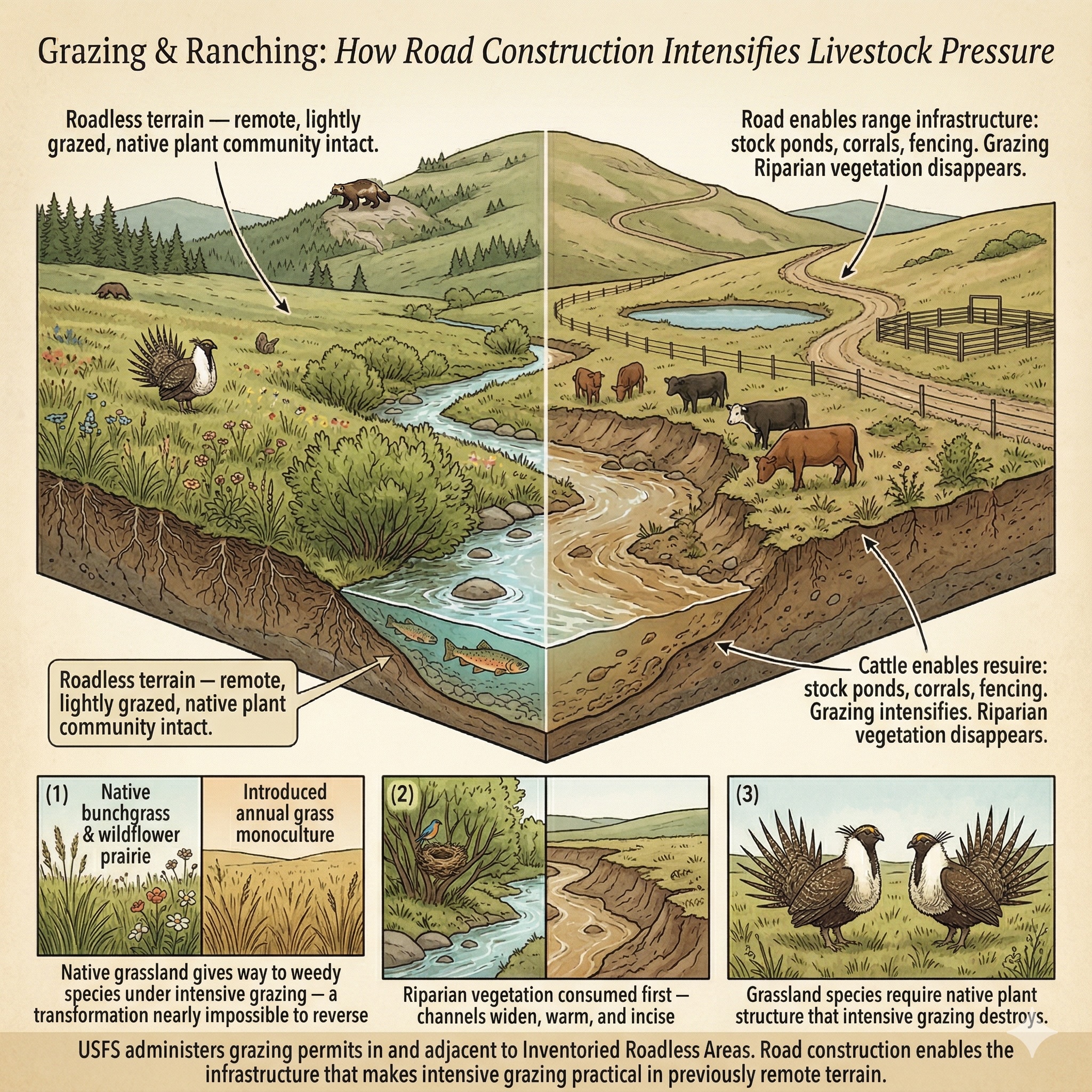
Road construction enables the infrastructure that intensifies grazing pressure in remote terrain historically too inaccessible for intensive management.
The Threat
The National Forest System is not only forests. It includes 193 million acres of land managed under a multiple-use mandate — and within that mandate, grazing has operated on national forest lands for over a century. The USFS administers thousands of livestock grazing permits across national forests and national grasslands, including in and adjacent to Inventoried Roadless Areas. Unlike timber harvest, grazing does not require road construction to occur. It is already happening.
What road construction changes is the intensity, infrastructure, and manageability of that grazing.
Range improvements — stock ponds, water developments, salt licks, corrals, and the fencing systems that control where livestock go — require construction access. Pipelines that deliver water to new grazing allotments need corridors. The management capacity to monitor, move, and support livestock across remote terrain expands dramatically when roads exist. Rescinding the Roadless Rule does not create grazing where none existed, but it enables the infrastructure buildout that intensifies grazing pressure in terrain that has historically been too remote for intensive management.
The ecological consequences of intensive grazing in previously lightly grazed roadless terrain are well documented. Livestock compact soils, reducing infiltration and increasing the runoff that roads themselves generate — the two effects compound each other. Streambanks are trampled, accelerating bank erosion and delivering sediment loads that rival road-generated inputs. Riparian vegetation — the willows, alders, and sedges that stabilize streambanks, shade water, and provide critical habitat for neotropical migrants and aquatic species — is preferentially consumed. Where riparian vegetation goes, the stream often follows: channels widen, incise, and warm.
On grassland roadless areas in particular — and the USFS manages twenty National Grasslands totaling nearly four million acres — the threat is not to forest structure but to native prairie. Native grassland communities are among the most imperiled ecosystems in North America. They evolved with periodic drought, fire, and the grazing of native ungulates. They did not evolve with yearround, high-density cattle grazing. The difference matters. Native bunchgrasses, forbs, and the insects, birds, and small mammals that depend on them give way to introduced annual grasses and weedy species under intensive grazing pressure — a transformation that, once accomplished, is extraordinarily difficult to reverse.
The official definition of 2.3 Terrestrial Animal Farming, Ranching & Herding covers "domestic or semidomesticated animals allowed to roam in semi-natural areas (ranching) or the wild and supported by natural habitats (herding)." The IUCN classification's own introduction notes pointedly that "even seemingly well-managed grazing regimes can be a threat to some elements of biodiversity in the system."
In the roadless areas covered by this application: 307 species carry documented grazing-related threats across 1,899 areas — including 84 critically imperiled (G1/T1) species and 134 federally listed species. For these organisms, the intensification of grazing pressure that road construction enables is not a marginal change. It is an infrastructure-driven transformation of the ecological conditions they depend on.
The Roadless Rule does not prohibit grazing. But it limits the infrastructure that enables grazing intensification in remote terrain. Road construction unlocks range development that the absence of roads has historically made impractical.
Severity of Impact
NatureServe rates the expected population decline for each species facing this threat, using the IUCN-CMP international standard.
Species at Risk
Imperiled species (G1-G3 or federally listed) with NatureServe-assessed threat records in this category. Sort and filter to explore.
| Species | Rank | ESA | Threat | Severity ▲ | Scope | Areas |
|---|---|---|---|---|---|---|
| Contra Costa Goldfields Lasthenia conjugens | G1 | E | 2.3 Livestock farming & ranching | Extreme - moderate | Pervasive - restricted | 6 |
| Glowing Indian-paintbrush Castilleja ornata | G1 | E | 2.3 Livestock farming & ranching | Extreme - moderate | Pervasive (71-100%) | 1 |
| Mineral Creek Mountainsnail Oreohelix pilsbryi | G1 | UR | 2.3 Livestock farming & ranching | Extreme - moderate | Pervasive (71-100%) | 1 |
| Ash Grey Indian-paintbrush Castilleja cinerea | G1 | T | 2.3 Livestock farming & ranching | Extreme - serious | Pervasive - large | 5 |
| Burke's Goldfields Lasthenia burkei | G1 | E | 2.3 Livestock farming & ranching | Extreme - serious | Pervasive - large | 7 |
| Howell's Spectacular Thelypody Thelypodium howellii ssp. spectabilis | T1 | T | 2.3 Livestock farming & ranching | Extreme - serious | Pervasive - large | 1 |
| Elusive Jacob's-ladder Polemonium elusum | G1 | 2.3 Livestock farming & ranching | Serious or 31-70% pop. decline | Large (31-70%) | 1 | |
| Fassett's Locoweed Oxytropis campestris var. chartacea | T1 | T | 2.3 Livestock farming & ranching | Serious or 31-70% pop. decline | Large (31-70%) | 1 |
| Green's Awnless Orcutt Grass Tuctoria greenei | G1 | E | 2.3 Livestock farming & ranching | Serious or 31-70% pop. decline | Large - restricted | 24 |
| Kern Primrose Sphinx Moth Euproserpinus euterpe | G1 | T | 2.3 Livestock farming & ranching | Serious or 31-70% pop. decline | Large - restricted | 6 |
| Munz's Onion Allium munzii | G1 | E | 2.3 Livestock farming & ranching | Serious or 31-70% pop. decline | Pervasive - large | 3 |
| Neosho Mucket Lampsilis rafinesqueana | G1 | E | 2.3 Livestock farming & ranching | Serious or 31-70% pop. decline | Large (31-70%) | 1 |
| Anthony's Riversnail Athearnia anthonyi | G1 | E, XN | 2.3 Livestock farming & ranching | Serious - moderate | Restricted (11-30%) | 6 |
| Benton County Cave Crayfish Cambarus aculabrum | G1 | E | 2.3 Livestock farming & ranching | Serious - moderate | Large (31-70%) | 1 |
| Eastern Black Rail Laterallus jamaicensis jamaicensis | T1 | T | 2.3 Livestock farming & ranching | Serious - moderate | Large - restricted | 29 |
| Epling's Hedge-nettle Stachys eplingii | G1 | 2.3 Livestock farming & ranching | Serious - moderate | Restricted (11-30%) | 3 | |
| Georgia Rockcress Arabis georgiana | G1 | T | 2.3 Livestock farming & ranching | Serious - moderate | Large (31-70%) | 3 |
| Kendall Warm Springs Dace Rhinichthys osculus thermalis | T1 | E | 2.3 Livestock farming & ranching | Serious - moderate | Pervasive (71-100%) | 5 |
| Masked Bobwhite Colinus virginianus ridgwayi | T1 | E | 2.3 Livestock farming & ranching | Serious - moderate | Pervasive - restricted | 1 |
| Neches River Rosemallow Hibiscus dasycalyx | G1 | T | 2.3 Livestock farming & ranching | Serious - moderate | Unknown | 1 |
| Blunt-nosed Leopard Lizard Gambelia sila | G1 | E | 2.3 Livestock farming & ranching | Serious - slight | Unknown | 1 |
| Chihuahua Chub Gila nigrescens | G1 | T | 2.3 Livestock farming & ranching | Serious - slight | Unknown | 3 |
| Chupadera Springsnail Pyrgulopsis chupaderae | G1 | E | 2.3 Livestock farming & ranching | Serious - slight | Large (31-70%) | 1 |
| Desert Pupfish Cyprinodon macularius | G1 | E | 2.3 Livestock farming & ranching | Serious - slight | Unknown | 8 |
| Giant Kangaroo Rat Dipodomys ingens | G1 | E | 2.3 Livestock farming & ranching | Serious - slight | Large - small | 15 |
| Agate Desert Lomatium Lomatium cookii | G1 | E | 2.3 Livestock farming & ranching | Moderate or 11-30% pop. decline | Restricted (11-30%) | 1 |
| California Dandelion Taraxacum californicum | G1 | E | 2.3 Livestock farming & ranching | Moderate or 11-30% pop. decline | Restricted (11-30%) | 2 |
| California Jewelflower Caulanthus californicus | G1 | E | 2.3 Livestock farming & ranching | Moderate or 11-30% pop. decline | Large (31-70%) | 14 |
| Clay Phacelia Phacelia argillacea | G1 | E | 2.3 Livestock farming & ranching | Moderate or 11-30% pop. decline | Large - restricted | 11 |
| Fish Slough Milkvetch Astragalus lentiginosus var. piscinensis | T1 | T | 2.3 Livestock farming & ranching | Moderate or 11-30% pop. decline | Restricted (11-30%) | 3 |
| Kelso Creek Monkeyflower Erythranthe shevockii | G1 | 2.3 Livestock farming & ranching | Moderate or 11-30% pop. decline | Large (31-70%) | 5 | |
| Laguna Mountains Skipper Pyrgus ruralis lagunae | T1 | E | 2.3.1 Nomadic grazing | Moderate or 11-30% pop. decline | Large (31-70%) | 2 |
| Long Valley Speckled Dace Rhinichthys nevadensis caldera | T1 | PE | 2.3 Livestock farming & ranching | Moderate or 11-30% pop. decline | Pervasive (71-100%) | 3 |
| Macfarlane's Four-o'clock Mirabilis macfarlanei | G1 | T | 2.3 Livestock farming & ranching | Moderate or 11-30% pop. decline | Small (1-10%) | 8 |
| Arroyo Toad Anaxyrus californicus | G1 | E | 2.3 Livestock farming & ranching | Moderate - slight | Restricted (11-30%) | 48 |
| Chipola Slabshell Elliptio chipolaensis | G1 | T, PDL | 2.3 Livestock farming & ranching | Moderate - slight | Restricted (11-30%) | 1 |
| Cracking Pearlymussel Hemistena lata | G1 | E, XN | 2.3 Livestock farming & ranching | Moderate - slight | Restricted - small | 1 |
| Cushion Bladderpod Physaria pulvinata | G1 | 2.3 Livestock farming & ranching | Moderate - slight | Large (31-70%) | 1 | |
| Dwarf Bear-poppy Arctomecon humilis | G1 | E | 2.3 Livestock farming & ranching | Moderate - slight | Restricted (11-30%) | 2 |
| Monte Neva Indian-paintbrush Castilleja salsuginosa | G1 | 2.3 Livestock farming & ranching | Moderate - slight | Large (31-70%) | 1 | |
| New Mexico Ridge-nosed Rattlesnake Crotalus willardi obscurus | T1 | T | 2.3 Livestock farming & ranching | Moderate - slight | Pervasive - restricted | 1 |
Townsendia lemhiensis | G1 | 2.3 Livestock farming & ranching | Slight or 1-10% pop. decline | Pervasive (71-100%) | 3 | |
| Black-footed Ferret Mustela nigripes | G1 | E, XN | 2.3 Livestock farming & ranching | Slight or 1-10% pop. decline | Pervasive - large | 3 |
| Bruneau Hot Springsnail Pyrgulopsis bruneauensis | G1 | E | 2.3 Livestock farming & ranching | Slight or 1-10% pop. decline | Small (1-10%) | 22 |
| Hawaiian Petrel Pterodroma sandwichensis | G1 | E | 2.3 Livestock farming & ranching | Slight or 1-10% pop. decline | Pervasive - large | 4 |
| Black Toad Anaxyrus exsul | G1 | 2.3 Livestock farming & ranching | — | — | 5 | |
| Cronquist's Woody-aster Xylorhiza cronquistii | G1 | 2.3.4 Scale unknown/unrecorded | Unknown | Pervasive - large | 1 | |
| Gray's Lily Lilium grayi | G1 | 2.3 Livestock farming & ranching | Unknown | Small (1-10%) | 10 | |
| Harrison's Thistle Cirsium harrisonii | G1 | 2.3 Livestock farming & ranching | Unknown | Pervasive (71-100%) | 2 | |
| Little Colorado Spinedace Lepidomeda vittata | G1 | T | 2.3 Livestock farming & ranching | — | — | 3 |
Showing top 50 species. Use filters above to narrow results.
Areas at Risk
Roadless areas where imperiled species face this threat, grouped by state.
Arizona (8)
| Area | Forest | Acres | Species at Risk |
|---|---|---|---|
| Tumacacori | Coronado National Forest | 44,594 | 15 |
| Chiricahua | Coronado National Forest | 76,876 | 12 |
| Galiuro | Coronado National Forest | 28,333 | 11 |
| Lower San Francisco | Apache-Sitgreaves National Forests | 59,310 | 10 |
| Mazatzal | Tonto National Forest | 16,942 | 10 |
| Whetstone | Coronado National Forest | 20,728 | 10 |
| Butterfly Roadless Area | Coronado National Forest | 42,296 | 9 |
| Hackberry | Coconino National Forest | 17,885 | 9 |
California (22)
| Area | Forest | Acres | Species at Risk |
|---|---|---|---|
| Woolstaff | Sequoia National Forest | 41,445 | 15 |
| Chico | Sequoia National Forest | 39,836 | 14 |
| Greenhorn Creek | Sequoia National Forest | 28,226 | 14 |
| Channell | Sequoia National Forest | 45,429 | 13 |
| Boundary Peak (CA) | Inyo National Forest | 210,884 | 12 |
| Domeland Add. | Sequoia National Forest | 3,046 | 12 |
| Fox Mountain | Los Padres National Forest | 52,072 | 12 |
| Mill Creek | Sequoia National Forest | 27,643 | 12 |
| Rincon | Sequoia National Forest | 54,610 | 12 |
| Sawmill - Badlands | Los Padres National Forest | 51,362 | 11 |
| Sespe - Frazier | Los Padres National Forest | 106,910 | 11 |
| Glass Mountain | Inyo National Forest | 52,867 | 10 |
| South Sierra | Inyo National Forest | 41,853 | 10 |
| Trabuco | Cleveland National Forest | 23,341 | 10 |
| Wildhorse | Cleveland National Forest | 1,483 | 10 |
| Antimony | Los Padres National Forest | 40,911 | 9 |
| Coldwater | Cleveland National Forest | 8,402 | 9 |
| Coyote Southeast | Inyo National Forest | 53,159 | 9 |
| Cuyama | Los Padres National Forest | 19,631 | 9 |
| Fish Canyon | Angeles National Forest | 29,886 | 9 |
| Log Cabin Saddlebag | Inyo National Forest | 15,165 | 9 |
| Lpoor Canyon | Los Padres National Forest | 13,762 | 9 |
Colorado (1)
| Area | Forest | Acres | Species at Risk |
|---|---|---|---|
| Dome Peak | Routt NF | 35,716 | 9 |
Idaho (1)
| Area | Forest | Acres | Species at Risk |
|---|---|---|---|
| Bear Creek | Caribou-Targhee National Forest | 118,582 | 16 |
Nevada (1)
| Area | Forest | Acres | Species at Risk |
|---|---|---|---|
| Bald Mtn. | Humboldt-Toiyabe National Forest | 41,598 | 12 |
New Mexico (6)
| Area | Forest | Acres | Species at Risk |
|---|---|---|---|
| Contiguous To Black & Aldo Leopold Wilderness | Gila National Forest | 111,883 | 12 |
| Peloncillo (NM) | Coronado National Forest | 43,339 | 12 |
| Contiguous To Gila Wilderness & Primitive Area | Gila National Forest | 79,049 | 11 |
| West Face Sacramento Mountains | Lincoln National Forest | 41,176 | 11 |
| Lower San Francisco | Gila National Forest | 26,460 | 9 |
| Meadow Creek | Gila National Forest | 34,167 | 9 |
South Dakota (1)
| Area | Forest | Acres | Species at Risk |
|---|---|---|---|
| Indian Creek | Buffalo Gap National Grassland | 24,666 | 43 |
Texas (1)
| Area | Forest | Acres | Species at Risk |
|---|---|---|---|
| Big Creek | National Forests in Texas | 1,447 | 12 |
Utah (9)
| Area | Forest | Acres | Species at Risk |
|---|---|---|---|
| Boulder Mtn. / Boulder Top / Deer Lake | Dixie National Forest | 110,690 | 13 |
| Pine Valley Mountains | Dixie National Forest | 57,673 | 13 |
| 0419020 | Ashley National Forest | 355,684 | 12 |
| Long Neck Mesa / Steep Creek / Oak Creek - Steep Creek / Oak | Dixie National Forest | 55,489 | 12 |
| Casto Bluff | Dixie National Forest | 87,466 | 11 |
| Lookout Peak | Fishlake National Forest | 9,195 | 10 |
| Thousand Lake Mountain | Fishlake National Forest | 27,267 | 10 |
| Box - Death Hollow | Dixie National Forest | 3,175 | 9 |
| Happy Valley | Dixie National Forest | 14,458 | 9 |
IUCN Threat Classification
Official definitions from the IUCN-CMP Unified Classification of Direct Threats.
2.3 — Terrestrial Animal Farming, Ranching & Herding (v4.0)
Co-occurring Threats
Roads rarely cause a single type of harm. This threat frequently co-occurs with:
Data Sources
- NatureServe Explorer: species threat assessments using IUCN-CMP v3.2
- IUCN-CMP Threat Category 2.3
- IUCN-CMP v4.0: Salafsky et al., Conservation Biology, 2025
Grazing & Ranching